The technical data sources listed below are used by the Water Supply Committee to prepare the comprehensive water supply outlook.
| Topic | Link | Description | Source |
|---|---|---|---|
| Weather | Idaho Annual Average Precipitation | Graphical map of Idaho’s annual average precipitation | IDWR |
| Drought | Drought Declarations Issued by IDWR | Idaho counties with Drought Emergency Declaration orders | IDWR |
| Rivers | River Flows for Recreationists | Flow in cubic feet per second (cfs) for rivers of local interest | USGS, USBR, Idaho Power |
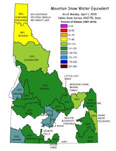
| Snow | Snow Water Equivalency | Weekly maps showing snowpack measurement in Idaho | IDWR |
| Reservoir Storage | Bear River “Teacup” Diagrams | Reservoir levels and average daily streamflows | BRCBear River Commission |
| Weather | Warnings and Watches: Southwest Idaho | Climate predictions for southwest Idaho | NOAA |
| Snow | Snow Cover Information (by location) | Graphic snow parameter for the Western United States and the Columbia Basin | NWS, NOAA |
| Weather | Warnings and Watches: Central Idaho | Climate predictions for central Idaho | NOAA |
| Weather | Warnings and Watches: Northern Idaho | Climate predictions for northern Idaho | NOAA |
| Weather | Warnings and Watches: Southeast Idaho | Climate predictions for southeast Idaho | NOAA |
| Weather | National 10-Day Precipitation Outlook | Graphical precipitation forecast | IGES |
| Weather | National 10-Day Temperature Outlook | Graphical temperature forecast | IGES |
| Weather | Northwest Weather Radar Image | Current weather radar image | NOAA, NWS |
| Rivers | River Flow Information (by river) | Real-time streamflow data | USGS |
| Reservoir Storage | Mackay Reservoir Levels | Data for the Mackay Reservoir near Mackay, Idaho | USGS |
| Snow | Snowpack Basin Index | Based on mountain data from NRCS SNOTEL sites | NRCS |
| Weather | Western Regional Climate Center | Climate data and predictions for the western United States | WRCC |
| Weather | El Niño and La Niña: Frequently Asked Questions | Commonly asked questions and their answers regarding El Niño and La Niñael nino, la nina | WRCC |
| Weather | National Long Range Precipitation & Temperature Outlook | One year outlooks in 90-day intervals | WRCC |
| Snow | Western US SNOTEL Information | Narrative and mapped SNOTEL climate information | WRCC |
| Weather | Idaho Climate Summaries | Interactive map of climate data | WRCC |
| Rivers | Colorado Basin River Forecast Center | River conditions in the Colorado Basin | NOAA |
| Weather | Climate Prediction Center | Climate predictions for the United States | NOAA |
| Weather | El Niño and La Niña: Basic Facts & Background | Advisories and predictions for El Niño and La Niña conditionsel nino, la nina | NOAA |
| Drought | Palmer Drought Index | Color-coded drought severity map of the United States | NOAA |
| Drought | Drought Assessment Information | Weekly United States drought assessment from the Climate Prediction Center | NOAA |
| Snow | National Snow Information | Daily snow depth and snow fall information from the Climate Prediction Center | NOAA |
| Rivers | River Flow Information (by river) | Real-time streamflow data | Idaho Power |
| Snow | Satellite Snow Cover Maps (by month) | Satellite areal extent of snow cover | NRCS, NWCC, NOAA |
| Snow | Basin Comparison Graphs | Links to time series plots of current water year basin snowpack and precipitation compared to other years | NRCS |
| Snow | Basin Projection Graphs | Links to time series plots of current water year basin snowpack and precipitation with non-exceedance for the remainder of the water year | NRCS |
| Rivers | Daily Guidance Streamflow Forecasts | Daily forecasts using SNOTEL data | NRCS |
| Rivers | Peak Streamflow for Individual Basins | Snow-Stream comparison graphs to monitor peak streamflows | NRCS |
| Snow | Idaho Snow Survey | Mountain snowpack data and streamflow forecasts for the western United States | NRCS |
| Snow | SNOTEL Interactive Map – Snow Water Equivalent (Station/Basin Conditions) | Interactive map showing daily station/basin snowpack measurement in Idaho | NRCS |
| Reservoir Storage | Pacific Northwest System Information | Reservoir Data is under Report List on this page from USCE | USCE |
| Rivers | Northwest River Forecast Center | River and hydrology 10-day and 120-day forecast points | NOAA |
| Weather | Idaho Evapotranspiration Charts | Crop water use charts | USBR |
| Reservoir Storage | Boise and Payette River Systems | Reservoir levels and average daily streamflows | USBR |
| Reservoir Storage | Upper Snake River System | Reservoir levels and average daily streamflows | USBR |
| Reservoir Storage | River Basin Reports | Near real-time Pacific Northwest water and environmental data | USBR |
| Rivers | Surface Water Data | Current and average streamflow and lake level data | USGS |
| Snow | West-wide Snowpack Map | Monthly mountain snowpack maps | NRCS |
| Rivers | Western U.S. Streamflow Forecast Map | Monthly streamflow forecasts | NRCS |
| Snow | Snow Water Equivalent % of Normal | Weekly maps showing snowpack measurement in Idaho | NRCS |
| Snow | SNOTEL Interactive Map – Snow Water Equivalent (Station Conditions) | Interactive map showing daily station snowpack measurement in Idaho | NRCS |
| Weather | Idaho Weather Forecasts | Detailed weather forecasts for Idaho | NOAA |
| Weather | Precipitation Forecasts | Quantitative precipitation forecasts for the United States | NOAA |
| Weather | Northwest Precipitation Outlook | Precipitation forecast updated every six hours | TWC/Intellicast |

