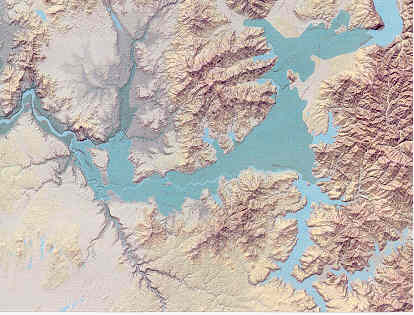
The Spokane Valley-Rathdrum Prairie (SVRP) aquifer underlies about 370 square miles of a relatively flat, alluvium-filled valley in a portion of northern Idaho and northeastern Washington. The aquifer consists of thick deposits of mostly coarse sediments (boulders, cobbles, and gravel) along with some sand and clay that were released from ancient Lake Missoula in northwestern Montana during multiple catastrophic failures of ice dams.
The SVRP supplies water to over 500,000 residents in Spokane County, Washington and Kootenai County, Idaho. The area includes the rapidly-growing cities of Spokane, Washington, Coeur d’Alene, Idaho, and Post Falls, Idaho. The SVRP was designated a “Sole Source Aquifer” by the Environmental Protection Agency in 1978 in response to local concerns about aquifer vulnerability to water quality degradation. Urban growth and increasing groundwater withdrawals and surface water appropriations raised concerns about water availability in the SVRP aquifer and declining streamflows in the Spokane and Little Spokane Rivers which have been shown to be hydraulically connected to the aquifer.
Water management of the SVRP aquifer occurs at federal, state, and local levels. The states of Washington and Idaho have primary responsibility for water allocation and water quality. However, local governments are increasingly called upon to consider water supply and quality implications in land use planning. The potential influence of the SVRP aquifer on surface water flows and quality further complicates aquifer management.
In 2001, two power companies applied for permits to divert a significant amount of groundwater (15 million gallons per day) in the Post Falls area. Their applications caused concern—especially related to the impacts that might occur to the lower Spokane River flows if the diversions were allowed. The permits were denied in 2002. However, their request put into motion the discussions about water use in the SVRP which ultimately led to the large-scale study that has taken place since.
The project provided a scientific foundation for managing the SVRP aquifer. The key objective was the development of a numerical groundwater model that Washington and Idaho can use to cooperatively manage the SVRP aquifer and adjacent rivers and lakes. To accomplish this objective, a number of sub-objectives (such as aquifer characterization, hydrologic data collection, water usage, and groundwater-surface water interactions) were identified and have been addressed over the course of the study.
In August 2003, a draft scope of work accompanied the appropriation request. The scope of work was based upon the assumption that the full requested appropriation would be forthcoming and that Washington and Idaho would contribute matching funds.
Work Plans
In Spring 2002, public meetings began with the purpose of discussing the future management of the water resources in the SVRP aquifer. Spurred on by the success of these meetings, Idaho’s US Senators secured $0.5 million in federal funding for the first phase of a regional aquifer study. Additional federal funding of $1.75 million and $0.15 million were provided in 2005 and 2007, respectively. Major accomplishments during this phase were:
- Geologic, hydrologic, and groundwater-flow information were compiled for Washington and Idaho. The study identified nine data needs, and most of these needs were addressed in later studies.
- A hydrogeologic framework and water budget were developed for the SVRP aquifer. The study identified three data needs, one of which became a major focus in Phase 2 (such as better estimates of seepage from Coeur d’Alene Lake and Lake Pend Oreille, and underflow from the aquifer into Long Lake).
- Monitoring wells were drilled during this time period (seven in Idaho), and both Washington and Idaho set up comprehensive groundwater monitoring networks.
- The groundwater-flow model was created and calibrated with existing groundwater-level data. The model results showed that simulated and modeled streamflow gains and losses and aquifer head were generally in agreement. The team recognized that the model had some uncertainties concerning the fluxes into the aquifer from Lake Coeur d’Alene and Pend Oreille.
- Spreadsheet tools were created to simulate various scenarios, and these indicated that withdrawals from Idaho and Washington will affect the streamflow in the Lower Spokane River in Washington.
Several studies were undertaken in this phase of the project. Some were completed and others are still in progress.
Coeur d’Alene Lake Water Budget
The USGS conducted a study on the water budget of Coeur d’Alene Lake for the time period from 2000-2005. The authors concluded that the difference between inflow and outflow values was less than one percent, and the amount of loss to the aquifer from the lake and the Spokane River was about four percent of the inflow.
Hydrogeologic Framework and Hydrologic Observations in the Coeur d’Alene to Post Falls area
Ralston Hydrologic Services, Inc. was contracted to complete two studies along the southern margin of the SVRP aquifer in Idaho.
- The first study focused on the hydrogeologic framework from the Idaho/Washington state line to Coeur d’Alene. Based on the work, Ralston recommended drilling several monitoring wells along the Spokane River from the Coeur d’Alene Lake outlet to Post Falls Dam in order to improve the understanding of leakage into the aquifer.
- The second study analyzed the groundwater elevations and water temperature relationships in the Coeur d’Alene Lake outlet area. The study concluded that, in general, groundwater levels are closely related to lake levels, although some anomalies in the degree of hydraulic connection were recognized. A second finding of the study became key for future technical work. Nimmer and Ralston (2008) used water temperature data from transducers deployed in wells on Blackwell Island to show that annual temperature fluctuations occurred in patterns that were similar to water level cycles. However, water temperature responses in individual wells were delayed with respect to the associated water level cycles. Some delays were only on the order of days whereas some delays were in the range of two to seven months.
Thermal Data Collection and Modeling in the Farragut State Park to Athol area

The recognition that cyclic water temperature signatures occur in manners similar to water level cycles brought about the idea of using temperature as a tracer for modeling groundwater flow in the aquifer and, ultimately, for determining the flux from the lakes into the aquifer. IDWR decided to apply the technique to Lake Pend Oreille first because the hydrogeology is less complex than in the Coeur d’Alene Lake outlet area, and because there are significantly fewer anthropogenic impacts in the Lake Pend Oreille area.
To accomplish this objective, more temperature data were needed. In mid-2008, only one well (Farragut #2) was being monitoring for water levels in Farragut State Park, which overlies the region where water flows laterally from Lake Pend Oreille into the aquifer. Since that time, Farragut #2 and four other wells in Farragut State Park have been instrumented with transducers for collecting continuous water level and water temperature data. Three of these wells were originally drilled for the US Navy in the 1940s for the Farragut Naval base and two were drilled for the Boy Scout National Jamboree in the late 1960s. Four of the wells are only used for monitoring and Farragut #2 is used occasionally for irrigation.

Data collected from the wells were used in a simple 1D model which indicated that there are strong thermal signatures in both the lake water and in the groundwater near the lake. These signatures have annual cycles of high and low water temperatures, both in the surface water and in the groundwater. Water temperatures in the lake are highest in the summer and lowest in the winter, as expected. However, water temperatures in the wells are coolest in the summer and warmest in the winter. The water levels in the wells match the lake levels (for example, both are high in the summer and low in the winter). This indicates that lake level changes are almost immediately transferred using pressure waves to the aquifer, but that changes in water temperature are delayed about six months because of the slower molecule-to-molecule transfer of heat. This relationship provides a better idea of the flux from the lake to the aquifer. The data and the model also show that the thermal signature is lost rapidly to the west because of temperature influences from the surface and from deeper in the earth. Therefore, we must understand the thermal signatures within a couple miles of the lake in order to best predict the flux.
New Monitoring Well Construction along the Spokane River near Coeur d’Alene

In December 2010, two new monitoring wells were completed about 1.5 miles northwest of the Coeur d’Alene Lake Outlet. The Centennial Trail well (120 feet deep) is located approximately 200 feet north of the Spokane River. The Prairie Trail well (176 feet deep) is located about 2,000 feet north/northeast of the Centennial Trail well. These wells are monitored for water levels and water temperatures in an effort to determine the hydrologic connection between the river and the aquifer in this area.
Current Status of Monitoring Network
With the addition of the two monitoring wells in the Coeur d’Alene area, the current monitoring network in Idaho consists of 28 wells. Most of the monitoring wells are unused and have pressure/temperature transducers deployed in them.
Additional technical work is needed to further refine estimates of flux from the two large lakes, and ultimately to improve the existing groundwater-flow model and spreadsheet tools in order to conduct more accurate aquifer stress simulations. Lack of funding is a major hurdle for the accomplishment of this work. Fortunately, the Kootenai Aquifer Protection District is providing funds for drilling one monitoring well. The State’s Aquifer Planning and Management Fund might pay for travel related to ongoing monitoring activities and for the replacement of monitoring equipment, when necessary. No other funding sources exist at this time for technical work.
Farragut Monitoring Well
The probable location for a new monitoring well is midway between the western end of Idlewild Bay and Farragut #5. The proposed well depth is 450 feet, extending about 100 feet into the aquifer so that transducers can be deployed at various elevations in the water column. The collection of temperature data in this manner will help define the nature of groundwater flow from the lake into the aquifer. The well was drilled in Summer 2011. The District’s funding was available until the end of September 2011.
Temperature Profiles at Farragut wells

IDWR conducted temperature profiles in several Farragut wells in March 2011 when water levels were at their lowest in the annual cycle. These profiles were compared to the profiles done the previous summer when water levels were at their peak. The temperature profiles provide additional information about water movement from the lake into the aquifer throughout the annual cycle.
Enhanced Thermal Monitoring
IDWR continues to assess the monitoring data and make adjustments with the transducer placements, as necessary. For example, the two transducers in the Highway 54 well were redeployed so that the vertical separation is about 30 feet instead of the previous separation of five feet. The Farragut #5 had a downhole camera survey conducted to see if it was free of debris or obstruction to determine whether the transducers could be deployed in the same manner as in the Highway 54 well. Water temperature data from the new Coeur d’Alene monitoring wells was analyzed throughout 2011, and adjustments were made to the transducer deployments, as necessary.
Thermal Modeling
Additional modeling were attempted using the HST3D and/or the MT3D models. Both are available for no cost to IDWR.
Well Deepening
As funding becomes available, the Highway 54 and Farragut #5 wells might be deepened 75 to 100 feet in order collect more water temperature data over the span of the water column.
Ongoing Data Collection
Monitoring wells with transducers are visited at least once per year for water level measurements by electric tape and transducer downloads. The wells without transducers are measured by electric tape three or four times per year.

