Official Government Website

Terminology

TermDefinition
AdjudicationAn adjudication is a court action for the determination of existing water rights which results in a decree that confirms and defines each water right.
Appropriated WaterIdaho water law is based on the appropriation doctrine because water rights in Idaho are based upon diversion and beneficial use of water. The appropriation doctrine has also been called "first in time is first in right" because the priority date determines who gets water when there is a shortage. A water right under Idaho law can be established only by appropriation, and once established, it can be lost if it is not used. See Idaho Code § 42-1502.
Artesian WellSee Idaho Code § 42-1604.
Basis of ClaimThe method that was used to establish your claim. Examples include prior decree, posted notice, beneficial use (historical) method, license, and permit.
Beneficial UseBeneficial uses include domestic use, irrigation, stock-watering, manufacturing, mining, hydropower, municipal, aquaculture, recreation, as well as fish and wildlife. The amount of the water right is the amount of water put to beneficial use. Because of the beneficial use requirement, a water right (or a portion of a water right) might be lost if it is not used for a continuous five-year period.
Change in Ownership or Address Idaho law requires new property owners to notify IDWR of any change in mailing address or change of ownership that applies to all water rights on file with IDWR. The process is especially important for claims filed as part of the Snake River Basin Adjudication (SRBA) or Coeur d'Alene-Spokane River Basin Adjudication (CSRBA). If your SRBA or CSRBA claim does not reflect your current address, you could miss out on important procedural notices that may directly affect your water right. If you buy property that has with it a water right, SRBA claim, or CSRBA claim, make certain that you are listed as the current owner and that your address is correct. If your water right is still pending before the SRBA or CSRBA court (for example, a partial decree has not yet been issued), there is no fee for filing the change of ownership form.
Consumptive UseSee Idaho Code § 42-202B.
CurtailmentReducing or restricting the use of surface or groundwater based on priority date.
de minimisThe water use is for a domestic use and/or stockwater use where the total volume of water diverted does not exceed 13,000 gallons per day. See Idaho Code &sec; 42-111.
Delivery CallA request from a water right holder for the administration of water rights under the prior appropriation doctrine. See IDAPA 37.03.11 for more detail.
Digital BoundarySee Idaho Code § 42-202B.
DiversionA diversion is a structure used to divert the water from its natural source. Typical diversion structures include pumps, headgates, ditches, pipelines, and dams—or some combination. A diversion is generally required to establish a water right. The Idaho Water Resource Board is authorized to acquire water rights without diversions. These water rights are called "instream flow" water rights and are typically authorized for purposes of protecting some public interest in a natural stream or lake such as recreation, wildlife, or natural beauty. A water right may also be acquired to water livestock directly from the stream which is called an "instream livestock" water right.
Domestic RightA domestic right is a right to the use of water for homes, organization camps, public campgrounds, livestock, and for any other purpose in connection with these uses including irrigation of up to one-half acre of land. See Idaho Code § 42-111.
Dual-Based ClaimsIn some cases, the federal government has claimed one right under two theories—a state law basis and a federal law basis. Both theories are reported on one form for that single water right. In most cases, the priority dates are different and are listed separately. The federal law basis is separately indicated in a box. IDWR does not investigate or make recommendations regarding federal law based claims.
Exceedence


Exceedence is a method describing the percentage of time for which an observed stream flow is greater than or equal to a defined stream flow. Exceedence is used when stream flow data are not normally distributed (such as on a bell-shaped curve). Most streams flows are not normally distributed because high flow events can skew the data making the mean flow greater than the median flow. Low-flow events have high exceedence percentages because, generally, observed flows exceed the low flow. High-flow events have low exceedence percentages because most observed flows are lower than the high-flow levels.


Example Stream Flow Chart for March


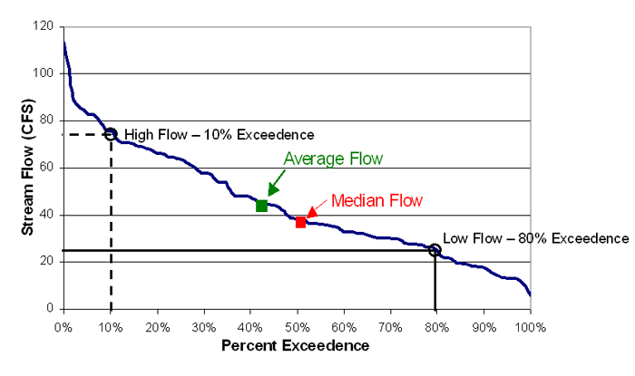
Data Points in the Example Stream Flow Chart for March


  • Mean Monthly Flow: 45 cfs

  • Median Monthly Flow: 38 cfs

  • 50% Exceedence Flow: 38 cfs (the median March flow for five out of every 10 years will be greater than or equal to 38 cfs)

  • 80% Exceedence Flow: 25 cfs (the median March flow will be equal to or greater than 25 cfs for eight out of every 10 years)

  • 10% Exceedence Flow: 75 cfs (the median March flow will be equal to or greater than 75 cfs for one out of every 10 years)

EvapotranspirationEvapotranspiration is the process of transferring moisture from the earth to the atmosphere by evaporation of water and transpiration from plants. Data quantification of water consumption from irrigated crops is derived from satellite imagery used in the IDWR mapping evapotranspiration process.
FloodplainA floodplain is land that could be submerged by floodwaters. The 100-year floodplain identifies the land in the floodplain subject to a one percent or greater chance of flooding in any given year.
Geothermal Resource WellsWells in Idaho with a bottom hole temperature of 212 degrees Fahrenheit or more are considered geothermal resource wells. See Idaho Code § 42-4002.
GroundwaterGroundwater is water that is located beneath the ground surface in soil pore spaces and in the fractures of lithologic formations. A unit of rock or an unconsolidated deposit is called an aquifer when it can yield a usable quantity of water. Groundwater is recharged from, and eventually flows to, the surface naturally; natural discharge often occurs at springs and seeps, and can form oases or wetlands. Groundwater is also often withdrawn for agricultural, municipal, and industrial use by constructing and operating extraction wells. The study of the distribution and movement of groundwater is hydrogeology (or groundwater hydrology). See Idaho Code § 42-230.
HydrologyHydrology is the study of the movement, distribution, and quality of water throughout the earth including the hydrologic cycle and water resources. A practitioner of hydrology is a hydrologist who works in the fields of earth science, environmental science, physical geography, geology, civil engineering, or environmental engineering.
Injection WellSee Idaho Code § 42-3902.
Instream Flow Water RightAn instream flow water right is a water right typically authorized for the purposes of protecting some public interest in a natural stream or lake such as recreation, wildlife, or natural beauty.
Instream Livestock Water RightAn instream livestock water right is a water right acquired to water livestock directly from the stream.
LateralA lateral is a ditch used to convey or deliver water—especially for irrigation purposes.
Low-Temperature Geothermal Resource Wells (LTG)Wells in Idaho with a bottom hole temperature of more than 85 degrees Fahrenheit and less than 212 degrees Fahrenheit are considered low-temperature geothermal resource wells. See Idaho Code § 42-230.
Mean High WatermarkSee Idaho Code § 42-3802.
Minimum Stream FlowSee Idaho Code § 42-1502.
Mitigation PlanA document submitted by a junior-priority groundwater right holder and approved by the Director (as provided in Rule 043) that identifies actions and measures to prevent, or compensate holders of senior-priority water rights for, material injury caused by the diversion and use of water by the junior-priority groundwater rights holders within an area having a common groundwater supply. See IDAPA 37.03.11 for more detail.
Municipal Provider See Idaho Code § 42-202B.
Name and AddressOn water right documentation, these fields display the most recent name and address on file with IDWR for the water right.
Nature of UseThe nature of use is the reason for diverting and using water. Examples are irrigation, domestic, stockwater, mining, municipal, and so forth.
Notice of ClaimA notice of claim to a water right is filed with IDWR in water rights adjudications. When an adjudication of a particular source is commenced, IDWR is required to notify the water users of the commencement of the adjudication, and notify the water users that they are required to file notices of claims for their water rights with IDWR. IDWR then investigates the notices of claims and prepares a report that is filed with the court. Claimants of water rights are notified of the filing of the report, and objections to the report may be filed with the court by anyone who disagrees with the findings in the report. If no objection is filed to a water right described in the report, then the court decrees the water right as described in the report. If an objection is filed to a water right described in the report, then the court determines the water right after a hearing and decrees the water right.
Public Land Survey System (PLSS)


The PLSS is used to describe and divide land in many states in the US. In Idaho, the initial point of the PLSS is near Kuna. From this point, the land is divided into 6×6-mile townships—which are further subdivided into 36 1×1-mile sections containing 640 acres each. One section can be subdivided into quarters which are 160 acres each, and which can be further subdivided into quarter quarters of 40 acres each. Each township is tied to the initial point and is identified by how many townships north or south as well as by how many ranges east or west they are from the initial point.


Public Land Survey System (PLSS)


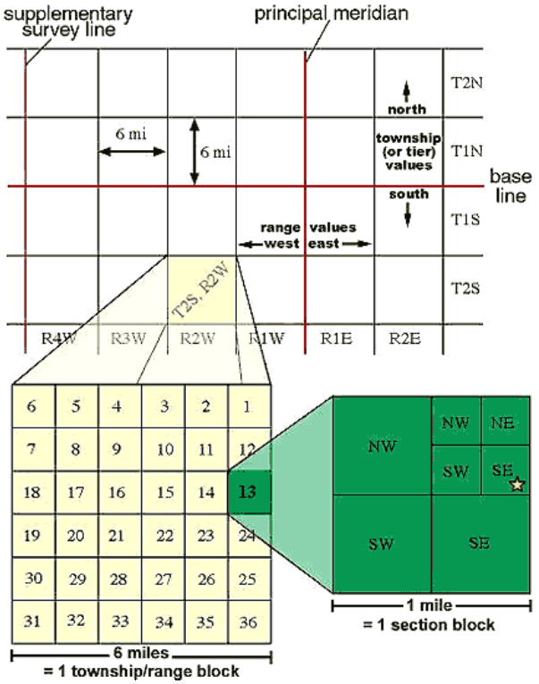
How to abbreviate PLSS locations

The Idaho State Capitol Building is located in Township 4 North, Range 2 East, Section 10—and in this section, it is located in the northwest quarter of the northeast quarter. This location can be abbreviated to T4N R2E Sec 10, NWNE.


Period of UseThe period of use is the time during the year when you can use the water for your right.
Place of Use (POU)The POU is the legal location where you use your water right and is generally described as quarter-quarter sections down to a 40-acre tract. Other legal descriptions that might be used are government lots, block, subdivision, parcel numbers, townsite names, mining claim information, homestead entry surveys, and other survey information.
Point of Diversion (POD)A POD is the legal location where you divert water from its source and is generally described as quarter-quarter sections down to a 40-acre tract or smaller. Other legal descriptions that might be used are government lots, block, subdivision, parcel numbers, townsite names, mining claim information, homestead entry surveys, and other survey information. Legal locations for instream flow claims are marked with a beginning point and an ending point.
Priority DateThe priority date is the date when the water right was established and it determines who gets water when there is a shortage. If there is not enough water available to satisfy all of the water rights, then the oldest (or senior) water rights are satisfied first and so on (in order) until there is no water left. When there is not enough water to satisfy all the water rights, new (or junior) water rights holders do not get water.
Purpose of UseThe general category for how a water right holder can make use of the water. Typical purpose of use categories include irrigation, domestic, or stock watering.
Public WatersIdaho's constitution and statutes declare all waters of the state when flowing in their natural channels, including the waters of all natural springs and lakes within the boundaries of the state and groundwaters of the state, to be public waters. Idaho's constitution and statutes also guarantee the right to appropriate those public waters. When a private right for the use of public waters is established by appropriation, a water right is established that is a real property right (much like property rights in land), and Idaho law protects real property rights. See Idaho Constitution Article XV and Idaho Code § 42 et al.
QuantityQuantity refers to the amount of water recommended in either cubic feet per second (cfs) and/or the volume of water in acre feet per year (AFY). Small domestic and/or stockwater claims is not to exceed 13,000 gallons per day.
Quarter SectionA division of a Section, a quarter section has an area of one-quarter-square mile (160 acres). Four quarter sections are within every land parcel delineated by a Section as part of the Public Land Survey System.
Quarter-Quarter SectionA division of a Quarter Section, a quarter-quarter section has an area of one-sixteenth square mile (40 acres). Four quarter-quarter sections are within every land parcel delineated by a Quarter Section as part of the Public Land Survey System.
Quarter-Quarter-Quarter SectionA division of a Quarter-Quarter section, a quarter-quarter-quarter section has an area of one-sixty-fourth square mile (10 acres). Four quarter-quarter-quarter sections are within every land parcel delineated by a Quarter-Quarter Section as part of the Public Land Survey System.
RangeRange lines are part of the Public Land Survey System. Range lines are drawn 6 miles apart in a north-south direction to help identify how far east or west a township is from the Boise meridian (the principal meridian used in Idaho that runs north-south through the city of Kuna). For example, T5N R20E is bounded on the east by the 20th range line counted toward the east from the Boise meridian.
Reasonably Anticipated Future Needs See Idaho Code § 42-202B.
Riparian RightsIn some states, a land owner has the right to make "reasonable use" of groundwater beneath his or her land, or water naturally flowing on, through, or along the borders of his or her land. A riparian right to make use of that water is not limited by priority date and it cannot be lost by non-use. Idaho law does not recognize a "riparian right" to divert and use water. A water right under Idaho law can be established only by appropriation, and once established, it can be lost if it is not used.
SectionA division of a land parcel delineated by a Township and Range, a section has an area of one-square mile (640 acres). Thirty-six sections are within every land parcel delineated by a Township and Range as part of the Public Land Survey System.
Service AreaSee Idaho Code § 42-202B.
SourceSource is the name and/or type of the source where you divert your water (for example, groundwater, unnamed spring, or Common Creek).
Statutory ClaimA statutory claim is filed with IDWR to make a record of an existing beneficial use right. In 1978, a statute was enacted requiring persons with beneficial use rights (other than water rights used solely for domestic purposes) to record their water rights with IDWR. The purpose of the statute was to provide some means to make records of water rights for which there were previously no records. However, these records are merely affidavits of the water users, and do not result in a license, decree, or other confirmation of the water right.
Stockwater RightA stock water right means a right to the use of water solely for livestock or wildlife.
StreamSee Idaho Code § 42-1502.
Surface WaterWater collecting on the ground or in a stream, river, lake, wetland, or ocean is surface water, and is related to water collecting as groundwater or atmospheric water. Surface water is naturally replenished by precipitation and naturally lost through discharge to evaporation and subsurface seepage into the groundwater.
TownshipTownship is land parcels six miles wide (east-west) and measure north and south from a reference line. Township is used in conjunction with Range as part of the Public Land Survey System which is used to delineate land based on a grid system.
Unappropriated WaterSee Idaho Code § 42-1502.
Water RightA water right is the right to divert public waters and put them to a beneficial use in accordance with one's priority date. See Idaho Code § 42-230.
Water Right NumberWater rights are identified by a number assigned by IDWR. The first two digits of a water right number represent the administrative basin number where the water right is located.
Well, Well Driller, or Well DrillingSee Idaho Code § 42-230.
ver: 3.5.1a | last updated:
Jump back to top of page button