 Official Government Website
What can we help you find?
Treasure Valley Groundwater Flow Model
Home » Hydrologic Projects » Treasure Valley Groundwater Flow Model
Hydrologic Projects
- Big Lost River Basin
- Camas Prairie Hydrologic Investigation
- East Ada County Hydrologic Project
- Eastern Snake Plain Aquifer Model
- Mountain Home Plateau
- North Ada County Hydrogeologic Investigation
- Portneuf River Basin Hydrologic Investigation
- Raft River Basin
- Spokane Valley-Rathdrum Prairie Hydrologic Project
- Treasure Valley Groundwater Flow Model
- Upper Salmon Hydrologic Project
- Western Snake Plain Aquifer Model
- Wood River Valley Groundwater-Flow Model
USGS published a data release of the final model in January 2023 and published the final model report in September 2023.
Final Treasure Valley Groundwater Flow Model
Upcoming Meetings
Related Documents
- Review of water availability in southern Ada and Canyon Counties (Memo) – December 29, 2015
- Bibliography of Sources for Treasure Valley Groundwater-Flow Model – June 8, 2017
- Ground Water Resources South of Lake Lowell (Memo) – May 21, 2021
- Treasure Valley Groundwater Recharge Scenario Modeling – April 30, 2024
Treasure Valley Hydrologic Project (1996-2004)
Summary
Treasure Valley Hydrologic Project Executive Summary (Petrich, 2004)
Summary of the Treasure Valley Water Summit – January 14-15, 2002
Treasure Valley Hydrologic Project AreaModeling
Simulation of Groundwater Flow in the Lower Boise River Basin (Petrich, 2004)
Simulation of Potential Increased Treasure Valley Groundwater Withdrawals Associated with Unprocessed Well Applications (Petrich, 2004)
TVHP Grid Expansion Report
TVHP Grid Expansion Report Appendix A
TVHP Grid Expansion Report Appendix B
PEST GridCharacterization
Characterization of Groundwater Flow in the Lower Boise River Basin (Petrich and Urban, 2004)
Appendix C. Construction Details for Dedicated, Multi-Level Piezometers
Water Quality Data for Monitoring Well TVHP #4 Municipal Park
Groundwater Recharge and Flow in the Regional Treasure Valley Aquifer System (Hutchings and Petrich, 2002)
Influence of Canal Seepage on Aquifer Recharge near the New York Canal (Hutchings and Petrich, 2002)Water Budget
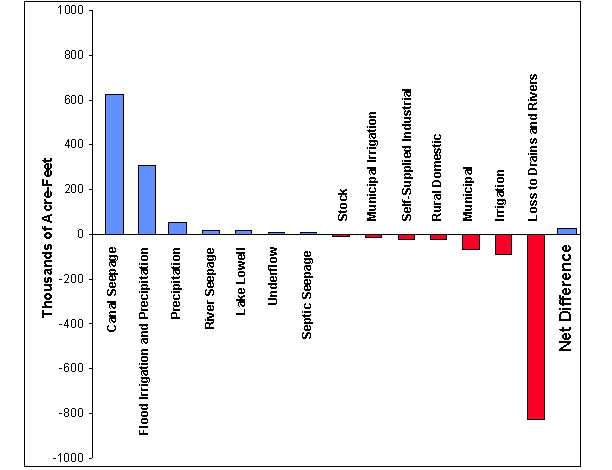
Water Budget for the Treasure Valley Aquifer System for the years 1996 and 2000 (Urban, 2004)
Water Budget Graph for the Treasure Valley Aquifer SystemMonitoring Well Construction
Hydrogeology, Geochemistry, and Well Construction of the Treasure Valley Hydrologic Project Monitoring Well #1, Ada County, Idaho (Dittus, Allred, and Squires, 1999)
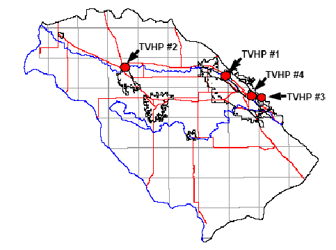
Treasure Valley Hydrologic Project #2 (Caldwell) Monitoring Well diagram
Treasure Valley Hydrologic Project #3 (Quarry View Park) Final Report (Scanlan, 2001)
Treasure Valley Hydrologic Project #4 (Municipal Park) Monitoring Well diagram
Multi-Level Monitoring WellsGeologic Framework
Geological and Geophysical Framework of the Treasure Valley: Reports on the Ontario, Parma, Notus and Boise Cross Sections (Buekelman, 1997)
Geologic and Tectonic History of the Western Snake River Plain, Idaho and Oregon (Wood and Clemens, 2003)
Stratigraphic Studies of the Boise (Idaho) Aquifer System using Borehole Geophysical Logs with emphasis on Facies Identification of Sand Aquifers (Squires and Wood, 2001)
Structure Contour Map of Base of the Quaternary Basalt, Murphy and west part of Mountain Home Sheets, Idaho (Wood, 1997)
Structure Contour Map of Top of the Mudstone Facies, Western Snake River Plain, Idaho (Wood, 1997)
Geologic Cross Section across the Treasure Valley, from 1.5 miles northwest of Star to the Snake River
Geologic Cross Section across the Treasure Valley, from 6 miles east-northeast of Star to the Snake River
Geologic Map of the Boise Valley and Adjoining Area, Western Snake River Plain, Idaho (Othberg and Stanford, 1992)
Treasure Valley Seismic Reflection Project UPRR 2000 Profile (Liberty and Wood, 2001)Image Data
Structure Contour Map of Base of the Quaternary Basalt, Murphy and west part of Mountain Home Sheets, Idaho (Wood, 1997)
Structure Contour Map of Top of the Mudstone Facies, Western Snake River Plain, Idaho (Wood, 1997)
Geologic Cross Section across the Treasure Valley, from 1.5 miles northwest of Star to the Snake River
Geologic Cross Section across the Treasure Valley, from 6 miles east-northeast of Star to the Snake River
Geologic Map of the Boise Valley and Adjoining Area, Western Snake River Plain, Idaho (Othberg and Stanford, 1992)
The Treasure Valley Modeling Technical Advisory Committee (TVMTAC) meets as needed.
Meeting dates, places, or times are subject to change.
Meeting Materials
Calibrated Model Release
Preliminary Calibration Figures
The links below contain compressed folders of figures reflecting the status of the TVGWFM calibration at the given dates.
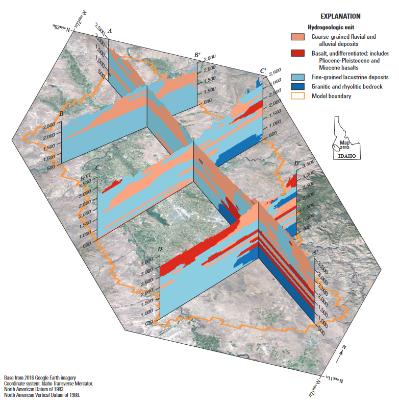
- Hydrogeologic Framework of the Treasure Valley and Surrounding Area, Idaho and Oregon: Scientific Investigations Report 2019-5138
- Boise Mountain Front Recharge: Treasure Valley Aquifer System Groundwater-Flow Model – February 20, 2019
- Design Objectives: Treasure Valley Aquifer System Groundwater-Flow Model – July 1, 2019
- A Groundwater-Flow Model for the Treasure Valley and Surrounding Area, Southwestern Idaho – April 2017