


Technical Publications
- Hydrologic Monitoring and Analyses, Phase 1 Final Project Report – June 2023
- Groundwater Surface Water Interactions Study, Phase 5 Final Project Report – August 2022
- Groundwater Surface Water Interactions Study, Phase 4 Final Project Report – December 2020
- Groundwater Surface Water Interactions Study, Phase 3 Final Project Report – June 2019
- Groundwater Surface Water Interactions Study, Phase 2 Support Final Report – December 2014
- Groundwater Surface Water Interactions Study – April 2014
- Hydrologic Analysis and Monitoring Phase IV – February 2012
- Optimizing Streamflow Enhancement Phase III – 2010
- Optimizing Streamflow Enhancement Phase II – 2008
Related Links
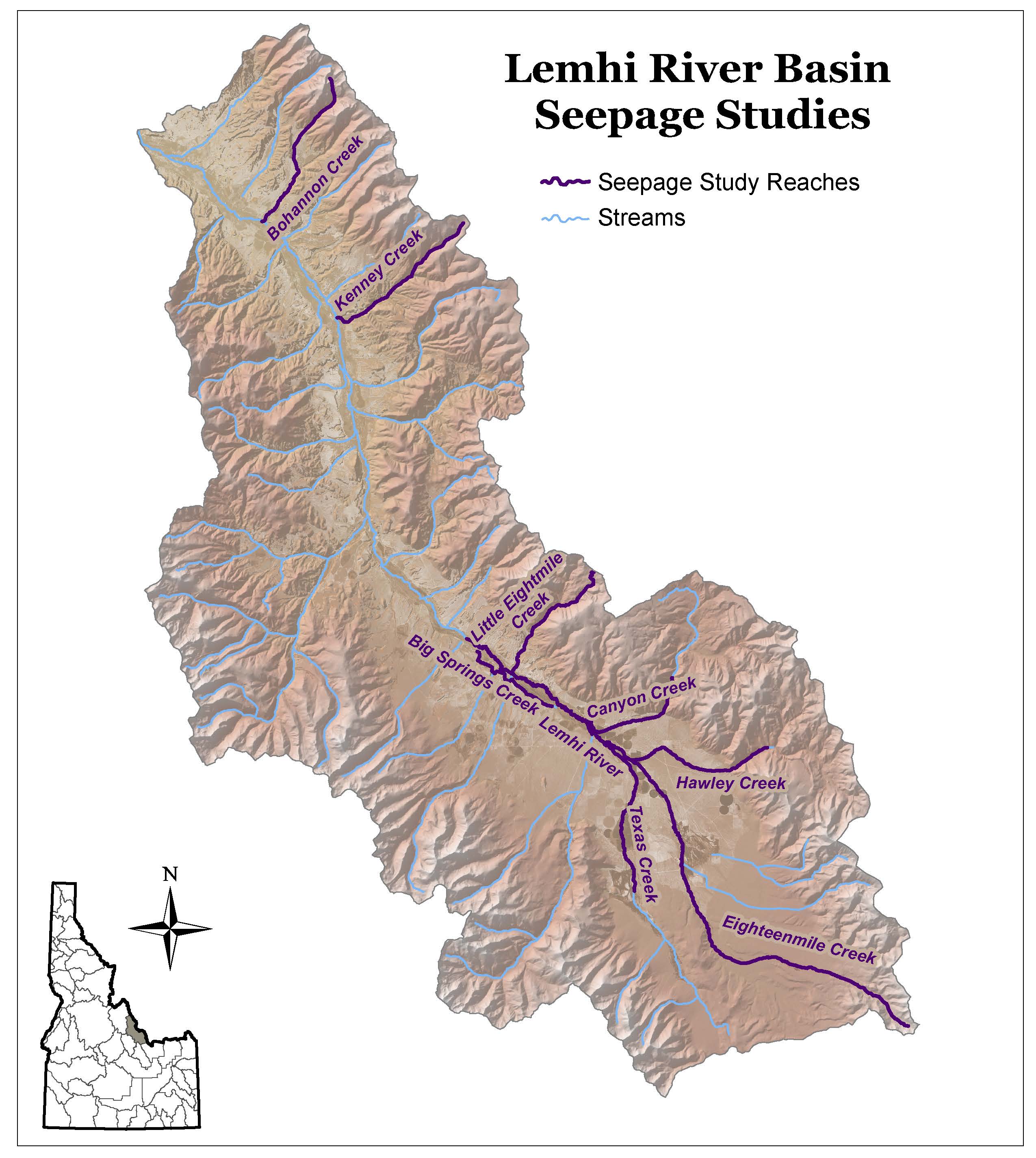
Lemhi River Basin Seepage Studies
The seepage studies provided here are brief reports that were incorporated into a final study report for the ongoing Optimizing Stream Flow Enhancement project funded by Pacific Coast Salmon Recovery Fund grants. The seepage studies in the Upper Salmon River Basin were conducted to gain an understanding of the surface water hydrology for a specific stream reach. Specifically, the data was needed to populate hydrology models and to guide decision-making by resource management agencies and landowners.
An understanding of the seasonal and spatial distribution of surface flows, reach gains, and reach loses revealed a greater understanding of the groundwater-surface water interactions. These seepage studies were conducted by measuring stream flow, diversions, surface returns from diversions, and tributary inflows within a short time period (typically one day). Seepage (gain or loss) for a reach was determined by deducting the inflows of tributaries and diversion returns and adding back in the outflows. The results are compared to measured flows at the bottom of the reach or sub-reach. If the calculated water at the bottom of the reach was greater than the measured, then there was a loss of flow to groundwater. If the summed values were less than the measured, then the stream was gaining flow from groundwater. Care was taken to ensure that the study represented gains and losses by monitoring stream gages and by re-measuring the stream flow at the upstream measuring point at the end of the study. This ensured that the differences between measurements were related to groundwater and surface water interaction and not to surface water changes.
Additional Information
Surface Water Modeling Projects
The surface water projects listed below use DHI’s MIKE Basin modeling software running in ESRI’s ArcGIS 9.2 or ArcView.
