


Listed below are Idaho’s designated Groundwater Management Areas.
Upcoming Meetings
| Area | Date Designated | Map | Hydrographs |
|---|---|---|---|
The Banbury Hot Springs GWMA, located in Twin Falls County in southern Idaho, was established on April 12, 1983. The resource was declared a GWMA because of declining artesian pressures and concern that over-utilization was being approached. On December 4, 1985, an order was issued staying the approval of pending water right applications and suspending further development under existing permits. This action essentially established a moratorium on further development. New water appropriations are allowed for domestic uses only. In 2011, IDWR amended the Order providing that approval of any application to appropriate low temperature geothermal water, including groundwater for domestic purposes, is stayed, with limited exceptions. Orders
Related Publications
For more information, visit the Geothermal Resource Wells page. | April 12, 1983 | Map | Hydrographs |
The Bear River GWMA is located in southeastern Idaho in portions of Bear Lake, Caribou, and Franklin Counties. The area was designated on August 12, 2001. The order also created the Bear River Water Management Advisory Committee. The committee completed its work in Fall 2002. And in February 2003, IWDR subsequently adopted a management plan based on the committee's recommendations. Orders & Management Plan
ToolsRelated Publications | August 12, 2001 | Map | Hydrographs |
The Big Wood River GWMA was designated on June 28, 1991 in order to address the connection between ground and surface water within the Camas Creek, Silver Creek, and Upper Big Wood River drainages above Magic Reservoir. IDWR determined that junior groundwater diversions were depleting senior surface water flows in the Big Wood River and Silver Creek. The Silver Creek and Big Wood River drainages had previously been designated as a CGWA on June 21, 1961; however, the designation was rescinded on January 26, 1966, at the request of local water users. An advisory committee was established for the Big Wood River GWMA in 2020. On May 4, 2022, IDWR issued an order approving the Big Wood River GWMA Management Plan through the end of 2024. The management policy associated with the June 28, 1991 management area designation was repealed by IDWR as part of a May 17, 2022 order establishing the Big Wood River GWMA Moratorium. On December 20, 2024, IDWR issued an order extending the Big Wood River GWMA Management Plan through the end of 2027. Orders
Advisory CommitteeRelated Publications
<a | June 28, 1991 | Map | Hydrographs |
The Boise Front Low-Temperature Geothermal Resource GWMA was designated on June 15, 1987 and is located in Ada County in southwestern Idaho. The order identified the resource of concern to be groundwater from a depth greater than 300 feet and/or a temperature greater than 85° Fahrenheit (F). On June 3, 1988, the Director signed a Management Policy for the GWMA. The policy identified specific goals and actions include protecting the existing users, allowing full use of the geothermal resource, providing clear management policies, and stabilizing depletions. On June 11, 1988, an order establishing a five-year moratorium (an action identified in the Management Policy) was issued. This order prevented new development or increased use of the resource. The moratorium has been extended for additional five-year periods since 1993. The most recent order issued in 2019 extends the moratorium to May 5, 2024. Orders & Management Policy
Related Publications
For more information, visit the Geothermal Resource Wells page. | June 15, 1987 | Map | Hydrographs |
IDWR conducted public meetings regarding the possible creation of a groundwater management area for the Eastern Snake River Plain Aquifer (ESPA). The ESPA stretches across a broad section of southern Idaho, from Ashton to King Hill, and is fed in large part by inflow from tributary basins. A groundwater management area is defined by Idaho Code § 42-233b as "…any groundwater basin or designated part thereof which the director of the department of water resources has determined may be approaching the conditions of a critical groundwater area." Idaho Code § 42-233a defines a critical groundwater area as "… any groundwater basin, or designated part thereof, not having sufficient groundwater to provide a reasonably safe supply for irrigation of cultivated lands, or other uses in the basin at the then current rates of withdrawal, or rates of withdrawal projected by consideration of valid and outstanding applications and permits, as may be determined and designated, from time to time, by the director of the department of water resources." The ESPA has declined significantly since the mid 1950s. Two key questions before the Director are: (1) whether the ESPA may be approaching the conditions of a critical groundwater area, and (2) if yes, what should be the boundary of the groundwater management area? Administrative & District Court Actions
Orders
| November 2, 2016 | Map | |
The Grand View-Bruneau GWMA is located in north-central Owyhee County, south of the Snake River. The management area was designated on October 29, 1982 because of increased and projected increases in groundwater withdrawal and declines in spring flows from the geothermal aquifer system. Since designation, the only new groundwater diversions are for domestic use and a Desert Land Entry development that is pending. IDWR also worked with well owners to eliminate leakage or unrestricted flow. A management plan has not been developed, nor has an advisory committee been formed. The impact of groundwater development on spring flows has been studied by various researchers as a result of the listing of the Bruneau Hot Springs snail as an Endangered Species in 1993. The snail's dependency on hot springs for its habitat has resulted in studies to evaluate the impact of groundwater pumping on spring discharges. Orders
Advisory CommitteeRelated Publications
| October 29, 1982 | Map | Hydrographs |
The Lewiston Plateau GWMA, designated on May 20, 2013, is located in Nez Perce County, south of the Clearwater River in the Lewiston area. The designation was made because of declining water levels in the shallow perched aquifers in the area. The Lewiston Plateau GWMA order rescinded the Lindsay Creek GWMA, located nearby. Applications to appropriate water within the GWMA can only be approved upon a determination that water is available and prior water rights will not be injured. The order designating the GWMA established an advisory committee to develop a management plan to manage the effects of groundwater withdrawal and protect existing water rights. The composition of the committee is specified in the order. The committee does not have any formal enforcement authority. Orders & Managements Plans
Related Publications
Advisory Committee Materials
| May 20, 2013 | Hydrographs | |
The Malad Valley GWMA, designated on November 4, 2015, is located in southeastern Idaho in portions of Oneida, Power, Bannock, and Franklin Counties. The GWMA boundary is all of IDWR Administrative Basin 15, and was established because of local concerns regarding declining water levels in the Malad Valley. The order also established the Malad Valley GWMA Advisory Committee. The composition and responsibilities of the advisory committee are specified in the order. The order established a two-year temporary moratorium on processing and approval of existing and new applications for appropriations of groundwater within the Malad Valley GWMA. The order includes guidance to administer the moratorium and defines exceptions to the water right moratorium for domestic and non-consumptive groundwater uses. The temporary moratorium was extended for five more years beginning on November 4, 2017. A management plan for the GWMA was approved on November 3, 2017. The management plan includes the creation of a water measurement district and groundwater level monitoring network; measurement of stream and spring flows throughout the Malad Valley; and, completion of an inventory of flowing artesian wells in the Malad Valley. The management plan also expresses support for a general adjudication of all water rights within the Malad Valley and a five-year extension of the temporary moratorium on new groundwater right permits in the Malad Valley. Orders & Management Plan
Related Publications
Advisory Committee Meetings
| November 4, 2015 | Map | Hydrographs |
Following the declaration of the Cinder Cone Butte CGWA, a study was conducted to evaluate the entire Mountain Home area. As a result of that 1982 study, the Mountain Home GWMA (which surrounds the Cinder Cone Butte area) was designated on November 9, 1982. The Mountain Home GWMA, located in Elmore and western Ada counties, was designated because of declining groundwater levels. The order states that the area is approaching critical, "although there appear to be subareas where new appropriations could be authorized without injuring existing water rights." A management policy was not included in the designation of the area. On June 6, 1996, IDWR issued an order establishing an advisory committee. The committee's objectives are to collect and review data; to mediate water-related issues involving water users; to develop draft groundwater management plan; to develop and propose implementation of a groundwater recharge program; and to serve as a forum for communication of water-related issues. The composition of the committee is specified in the order, and the committee does not have any formal enforcement authority. Orders
Related PublicationsFor related information, visit the Cinder Cone Butte CGWA page. | November 9, 1982 | Map | Hydrographs |
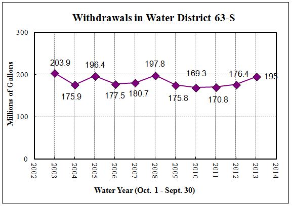
The Rathdrum Prairie GWMA is located in portions of Kootenai and Bonner Counties. IDWR designated the area on December 11, 2002. On September 15, 2005, IDWR adopted the groundwater management plan which is based on recommendations submitted by the Rathdrum Prairie Groundwater Advisory Committee. An element of management plan is a requirement for some new water right applications to include water conservation plans. A draft document titled "Water Conservation Measures and Guidelines for Preparing Water Conservation Plans" was prepared under the guidance of the advisory committee and is currently under review. A comprehensive hydrologic study began in 2003 and concluded in 2007. Orders & Management Plan
Subarea Reports
Related Publications
For related information, visit the Spokane Valley-Rathdrum Prairie Hydrologic Project page. | December 11, 2002 | Map | Hydrographs |
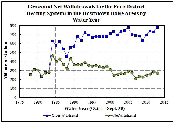
The Southeast Boise GWMA, located in Ada County, was established on October 14, 1994. The Order establishing the management area and included the requirement for the formation of an advisory committee. This precedent-setting requirement delineated the responsibilities and membership for the advisory committee. On March 9, 2001, the advisory committee submitted a management plan for the GWMA. IDWR subsequently adopted the plan in September 2002. The Order also required that all groundwater users diverting more than 0.20 cubic feet per second (cfs) submit annual reports of water use to IDWR. A separate Order requiring measuring devices, signed on April 4, 1995, was issued to 17 groundwater users holding a total of 28 water rights diverting more than 0.20 cfs. The Southeast Boise GWMA is the second groundwater management area in the Treasure Valley. The Boise Front Geothermal GWMA, designated in 1987, is for groundwater with temperatures greater than 85° F. The Southeast Boise GWMA designates a specific cold water aquifer unit, commonly described as the Boise-Fan aquifer. The boundaries of the two GWMAs partially overlap. Orders & Management Plan
Related Publications
| October 14, 1994 | Map | Hydrographs |
The Twin Falls GWMA is located in Twin Falls County in southern Idaho. It was established on January 11, 1984 based on concern that the thermal system was approaching a critical condition evident by declining pressures and that well interference might occur. The order specifically excluded the Banbury Hot Springs GWMA. A moratorium on new geothermal development was established on July 24, 1987 for a limited area within the GWMA. The moratorium was extended in 1992, 1997, 2002, 2007, 2008, 2013, and 2018 because equilibrium had not been established in the geothermal system. A management plan has not been developed, nor has an advisory committee been formed. Orders
Related Publications
For more information, visit the Geothermal Resource Wells page. | January 11, 1984 | Map | Hydrographs |
