

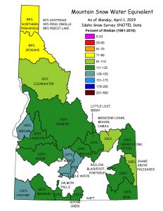

Listed below are the basins with comprehensive plans.
| Date | Basin Plan | Basin Map | Description |
|---|---|---|---|
| June 29, 1990 | South Fork Boise River Basin Plan | Basin Map | The South Fork Boise River is a major tributary of the Boise River, and its confluence with the Boise River is inundated by the Arrowrock Reservoir. The 1,310-square mile basin is mountainous with an extensive network of perennial streams. A major portion of the basin is covered by timber. The USDA Forest Service administers about 80% of the total land area. Timber harvest, recreation, and grazing are major activities in the basin. Two major storage reservoirs, Anderson Ranch and Little Camas, provide for irrigation, recreation, and flood control. |
| December 1992 | Henrys Fork Basin Plan | Basin Map | The Henrys Fork is a major tributary of the Snake River, draining about 3,200 square miles in Idaho and Wyoming. Land use is timber production and grazing in the uplands, with both irrigated and dry-land farming in the lower plains. The recreational resources in the upper basin are outstanding, with international recognition for quality fishing experiences. |
| December 1992 | Upper Boise River Basin Plan | The Upper Boise River basin lies above Lucky Peak dam and includes the North and Middle Forks of the Boise River and the Mores Creek drainage. The basin is about 1,375 square miles, and streams drain into the Lucky Peak Reservoir-Arrowrock Reservoir complex. Upstream of the reservoirs, the river and its tributaries contain excellent populations of wild rainbow trout and bull trout. Over 90% of the land is in public ownership, and a portion lies within the Sawtooth Wilderness Area. The Upper Boise River basin provides a variety of recreational settings and experiences. | |
| December 12, 1993 | Middle Snake River Basin Plan | Basin Map | The Snake River from Milner Dam to King Hill is delineated by the Snake River canyon with numerous springs which issue through the canyon walls. Water flow is dependent on releases from Milner Dam and return flows from the Snake River Plain aquifer. Agriculture is the dominant industry of the region, but the river serves other values as well. The river is home to a rich variety of fish and wildlife, and it provides recreational opportunities for residents. However, water quality degradation is a major concern that impacts all uses. |
| 1995 | Priest River Basin Plan | Basin Map | The Priest River basin lies in the Panhandle of Idaho, with small portions of the basin in Washington state and British Columbia, Canada. Upper Priest Lake and Priest Lake, the third largest natural lake in Idaho, are located in the upper half of the basin. Approximately 90% of the basin is publicly owned land, and numerous special management areas protect exemplary forest and wetland communities. The basin contains outstanding aesthetic quality, fish and wildlife habitat, and recreational opportunities. Timber and tourism are the two major industries in the basin. |
| January 12, 1996 | North Fork Clearwater River Basin Plan | Basin Map | The North Fork Clearwater River basin, from its headwaters in the Bitterroot Mountains to its western boundary at the confluence with the main Clearwater River below Orofino, encompasses approximately 2,500 square miles. Above Dworshak Reservoir, the basin is predominately public land managed by the US Forest Service, with the remainder of land mostly in private ownership. While timber is the predominant land use and industry in the basin, recreation is also a major use and a growing industry. |
| December 13, 1996 | South Fork Snake River Basin Plan | Basin Map | The South Fork Snake River originates in Yellowstone National Park and the basin encompasses all land draining into the river from the Idaho-Wyoming state line to the confluence with Henrys Fork. Water flow of the river is regulated by Palisades and Jackson Lake dams. Dry-land and irrigated agriculture is a predominant land use. The basin has many natural resource values: outstanding scenery, a quality fishery, and wildlife values provide diverse recreational opportunities. |
| February 5, 1999 | Payette River Basin Plan | Basin Map | The Payette River is a major tributary to the Snake River, draining about 3,320 square miles in west-central Idaho. Three major branches, the North, Middle, and South Forks, convey waters from the mountainous headwaters and converge to form the Payette River. Cascade Reservoir is the largest reservoir in the basin, and there are 25 additional water storage projects that provide for a variety of water uses. About 60% of the basin is publicly owned. Major industries are agriculture, timber, and recreation. Outstanding resources include bull trout focal habitat, bald eagle nesting, and the basin offers outstanding boating and fishing opportunities. |
| September 19, 2001 | Little Salmon River Basin Plan | Basin Map | The 576-square mile basin is located in northeastern Adams and southwestern Idaho Counties, and flows into the Salmon River at the northern side of Riggins (RM 86.7). The basin is mountainous and sparsely populated. Occupations in ranching, logging, and lumber manufacturing contribute to the basin's economy. Tourism and related services are becoming more important locally, potentially helping to support the area during downturns typically experienced by natural resources-based economies. |
| January 13, 2005 | South Fork Clearwater River Basin Plan | Basin Map | The South Fork Clearwater River basin has two distinct parts. The northwestern portion, the Camas Prairie, is rolling plateaus and prairies, and a major dry land agricultural area of the State of Idaho. It accounts for about 20% of the basin's land area. The eastern portion is forested, mountainous and sparsely populated with about 68% of the land area within the Nez Perce National Forest. The South Fork Clearwater River Plan was adopted by the Idaho Water Resource Board in 2004 and approved by the legislature in 2005. |
