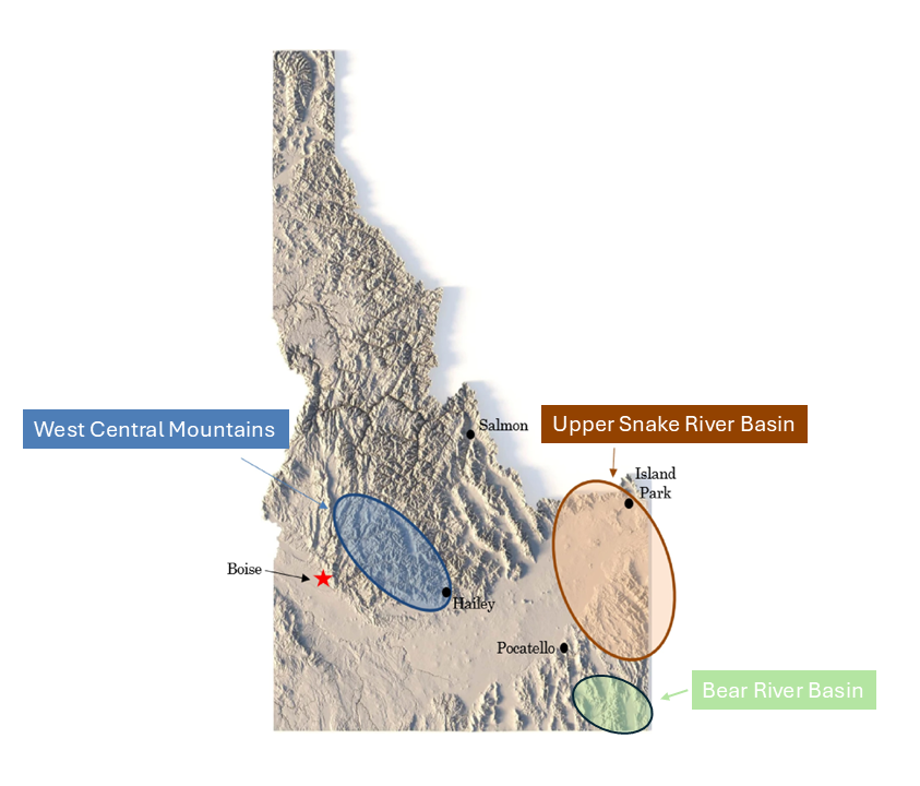
Figure 1. Cloud seeding operational areas in Idaho
Who Conducts Cloud Seeding in Idaho?
Collaborative Cloud Seeding Program
The Collaborative Cloud Seeding Program (Collaborative Program) is a unique partnership between the Idaho Water Resource Board (IWRB), Idaho Power Company (IPC), and local water users, for the operation of precipitation enhancement projects in the Upper Snake, Boise, and Wood River basins. The Collaborative Program is operated by IPC, while the IWRB facilitates the program and provides funding support. Additional funding contributions are supported by local waters in each basin. IPC additionally operates an independent project in the Payette River basin, in coordination with the Collaborative Program. The objective of the program is to augment snowpack, thereby enhancing runoff, in the project basins . The Collaborative Program currently has operations in 2 general regions of Idaho: the West Central Mountain region, including the Boise and Wood River Basins; and the Eastern Mountain region, comprised of the Northern and Southern Upper Snake River Basin. Cloud seeding operations are conducted regionally to allow for the efficiency of operations, and to allow for a cost sharing between basins, as instrumentation and equipment can be shared across a region to target seedable storms.
Figure 2. West Central Mountain Region map (provided by IPC)
Figure 3. Eastern Mountain Region map (provided by IPC)
West Central Mountain Region:
Boise River Basin
Wood River Basin
Payette River Basin
Eastern Mountain Region:
Northern Upper Snake River Basin
Southern Upper Snake River Basin
Idaho Power Company (IPC)
Idaho Power Company (IPC) is authorized by the IWRB to conduct cloud seeding operations in the Payette River Basin. This project is managed independently by IPC, though operated in coordination with the Collaborative Cloud Seeding Program.
High Country Resource Conservation & Development (HCRCD) Program
High Country Resource Conservation & Development (HCRCD) is authorized by the IWRB to cloud seed in the Upper Snake River Basin. HCRCD is operated by a private company called Let It Snow, which has been in operations for over 20 years. IPC provides forecasting support to the Upper Snakes HCRCD program. However, HCRCD operate their manual ground generator cloud seeding program independently. The HCRCD operates in coordination with the Collaborative Cloud Seeding Program.
State of Utah’s Northern Utah Program in Idaho
The Utah Division of Natural Resources (UT DNR) is authorized by the IWRB to conduct ground seeding operations in Idaho.
There are 3 authorized manual ground generators stationed in Idaho close to the border of Southern Idaho. This infrastructure is utilized to support the Northern Utah Cloud Seeding Program in Cache and Box Elder County.
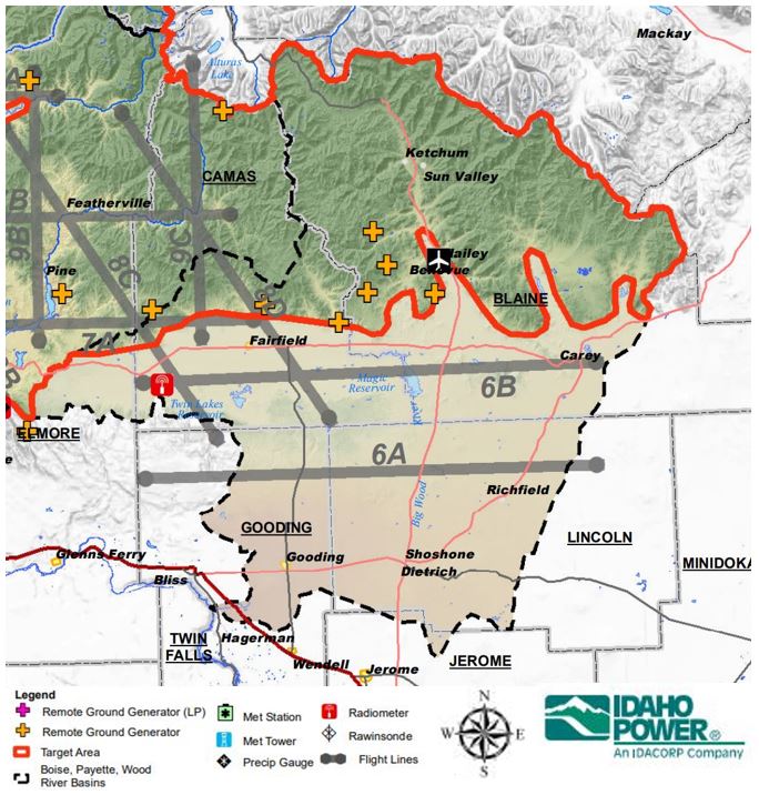
Figure 5. Wood River Basin cloud seeding operations map (provided by IPC)
The Wood River Basin project is a part of the Collaborative Cloud Seeding Program project, operated a part of the West Central Mountain region.
Figure 6. Wood River Basin project costs summary to date
Current Annual Basin: ~$769,000
Wood River Basin Infrastructure:
1 Shared Aircraft- Boise (B)
3 Shared Generators (3B)
7 Dedicated Generators
Boise River Basin
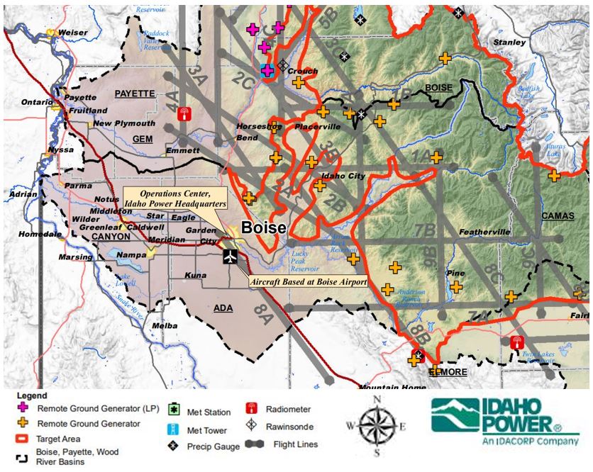
Figure 7. Boise River Basin cloud seeding operations map (provided by IPC)
The Boise River Basin project is part of Collaborative Cloud Seeding Program, operated as part of the West Central Mountain Region.
Figure 8. Boise River Basin project costs summary to date
Current Annual Basin: ~$1,025,000
Boise River Basin Infrastructure:
1 Shared Aircraft- Payette (P)
1 Shared Aircraft- Wood (W)
12 Shared Generators (9P/3W)
5 Dedicated Generators
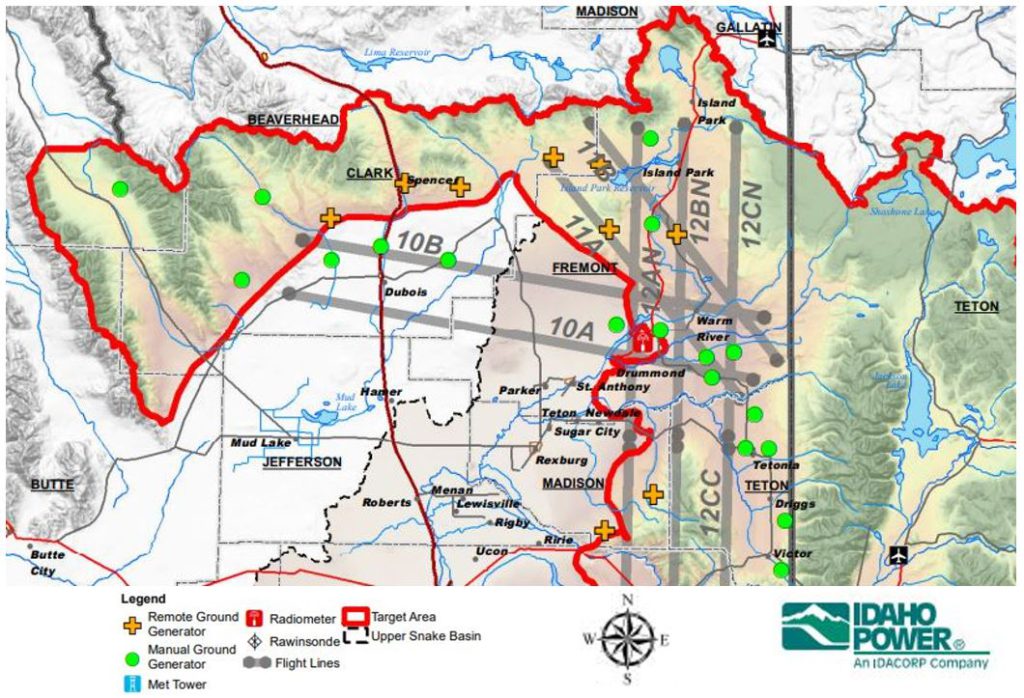
Upper Snake River Basin
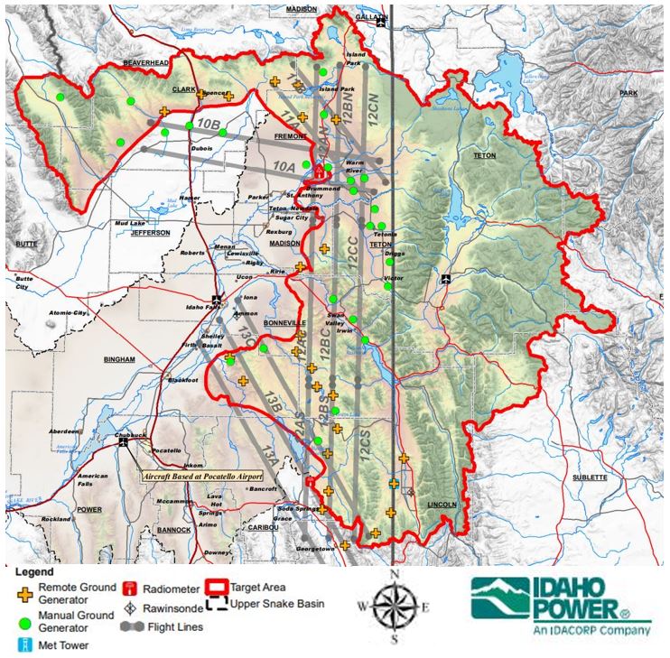
Figure 9. Upper Snake River Basin cloud seeding operations map (provided by IPC)
Northern Upper Snake River Basin
Figure 10. Northern Upper Snake River Basin cloud seeding operations map (provided by IPC)
Southern Upper Snake River Basin
Figure 11. Southern Upper Snake River Basin cloud seeding operations map (provided by IPC)
Figure 12. Upper Snake River Basin project costs summary to date
The Upper Snake River Basin project is a part of the Collaborative Cloud Seeding Program. The Upper Snake River Basin is a part of the Eastern Mountain cloud seeding region, with 2 sub regions of operation. The HCRCD are also authorized by the IWRB to independently operate a manual generator cloud seeding program in this region, operated by Let It Snow.
Current Annual Costs: ~$1,816,000
Upper Snake River Infrastructure:
1 Dedicated Aircraft
25 Dedicated Remote Ground Generators
23 Dedicated Manual Ground Generators (HCRCD)
Payette River Basin
Figure 13. Payette River Basin cloud seeding operations map (provided by IPC)
The Payette River Basin project is operated and managed independently by the IPC. The Payette River Basin project is operated in coordination with the Collaborative Program, as a part of the West Central Mountain region.
Payette Rive Basin Infrastructure:
1 Shared Aircraft: Boise (B)
9 Shared Generators: 9 (B)
7 Dedicated Liquid Propane Generators
8 Dedicated Generators
Basins of Interest
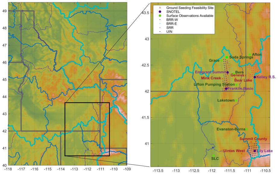
The IWRB is currently investigating the potential for cloud seeding to support water supply enhancement in other basins of Idaho. Areas of interest include the Bear River Basin (Bear) and the Lemhi River Basin (Lemhi).
The Bear River Basin feasibility and design study was initiated in 2021, with an objective of determining whether cloud seeding in the Bear is a cost effective measure for supporting Idaho’s water supply needs in this basin. The IWRB is additionally investigating cloud seeding to support water supply needs in the Lemhi River Basin.
Figure 14. Map of the Bear River Basin (provided by the National Center for Atmospheric Research)
Bear River Basin
The Bear River Basin is an area of interest for potential cloud seeding operations. The Collaborative Cloud Seeding Program conducted a Bear River Basin feasibility and design study that was initiated in 2021. The study determined that the Bear River Basin was a viable area to cloud seeding. The Bear River Basin is not yet apart of the Collaborative Cloud Seeding Program and is not currently operational for cloud seeding.
Figure 15. Map of the Lemhi River Basin (provided by the National Center for Atmospheric Research)
Lemhi River Basin
The Lemhi River Basin is another area of interest for potential cloud seeding operations. The Collaborative Cloud Seeding Program is currently conducting a Lemhi River Basin feasibility and design study to determine if this basin is viable for cloud seeding operations. The Lemhi River Basin feasibility and design was imitated in 2022 and still actively investigating.


 Official Government Website