Research is critical for designing, developing, operating, monitoring, and assessing an effective cloud seeding program. Research helps the Idaho Water Resource Board (IWRB) address policy questions and public concerns; and to ensure the objectives of water supply enhancements are sufficiently being met in regions where operations occur.
The SNOWIE research project served as a catalyst across the drought stricken western United States. Suddenly there was proof of a method to bring more water to basins in need. Cloud seeding has been proven to work… but “how well does it work?” Quantification of the effects from cloud seeding is currently the next big evolution in the science of cloud seeding. Conducting research provides data, which can then be used to develop models that will ultimately help the IWRB understand how much water is being generated, and how it may effect water supply in a the system.
Models are also essential for forecasting storms to inform cloud seeding operations, determining the feasibility of new projects and developing project designs, and assessing broad potential for cloud seeding across a region.
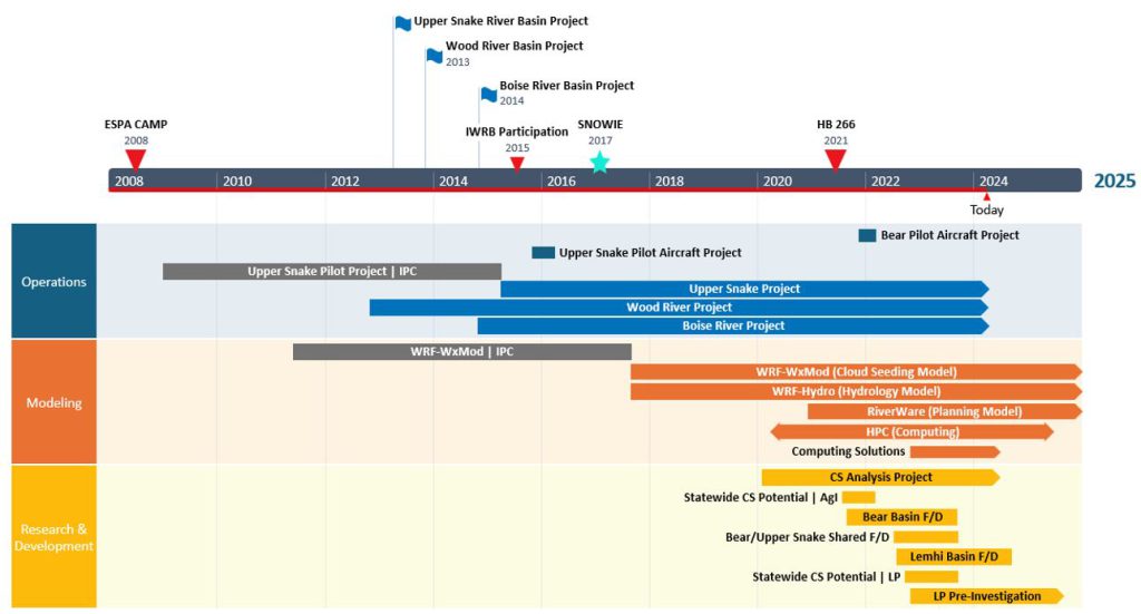
Figure 1. Timeline of the Idaho Water Resource Boards research and development projects
Current Research Projects
- Cloud Seeding Analysis
- Statewide Assessment of Cloud Seeding Opportunities
- Bear River Basin Feasibility and Design
- Upper Snake River Basin/Bear River Basin Feasibility and Design
- Lemhi River Basin Feasibility and Design
- Statewide Cloud Seeding Potential / Liquid Propane
- Liquid Propane Investigation
Modeling Projects
- Weather Research & Forecasting (WRF) model
- WRF-WxMod (Cloud Seeding Model)
- WRF-Hydro (Hydrology Model)
- RiverWare (Upper Snake River Planning Model)
- High Power Computer/Computing Solutions
Research Projects
Cloud Seeding Analysis
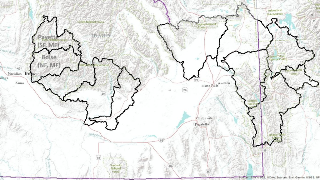
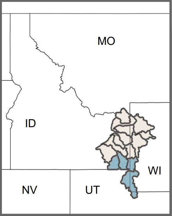
Figure 2. Map of the regions targeted by cloud seeding operations in Idaho for the Cloud Seeding Analysis project
In 2019, the Idaho Water Resource Board (IWRB) directed staff to conduct an investigation of cloud seeding in the basins where collaborative cloud seeding operations are conducted. The IWRB contracted with the National Center for Atmospheric Research (NCAR) to develop modeled cloud seeding data, as well as a WRF based hydrologic model, that can be used estimate the amount of water resulting from cloud seeding. The objective of the Cloud Seeding Analysis project is to determine how increased water supply from cloud seeding (CS) effects the hydrology and use of water in the targeted basins; and to determine the cost effectiveness of cloud seeding as a water management tool for Idaho.
Resources:
To understand how increased water supply generated from cloud seeding may effect the water supply in basins where operations occur, 3 separate components must be analyzed.
1. How much did precipitation increase?
- The science for proving CS works is very new; there is much more to learn about how cloud works.
- The IWRB must understand how it works so that models can be taught to replicate the process.
- Only then can we better simulate how cloud seeding will change precipitation.
- Target/Control is a statistical method used for evaluating changes in precipitation from cloud seeding. Idaho has decades of operational data to estimate the % change in snowpack in the target regions.
- The IWRB is currently working in partnership to develop a physically based cloud seeding model, supported by observational data, to answer this question with more granularity in the future.
2. How much water did the increase in precipitation add to the system?
- In a natural system, not all precipitation will make it to streamflow.
- A hydrologic model informed by atmospheric data (WRF-Hydro) is currently under development to better address this question.
3. Where does the increase in supply go?
- Hydrologic systems are dynamic and complex, which require significant data and modeling tools
- Before the IWRB can assess how cloud seeding will affect the hydrology of a system, the IWRB must first be able to model the system in its current state.
- Once the system can be replicated with some level of accuracy, the IWRB must test how sensitive the system is to change. How does the system work if a few knobs are turned… like adding water.
- With a replica of the hydrologic system, we can then input cloud seeding data to assess the effects of increased supply from cloud seeding.
Statewide Assessment
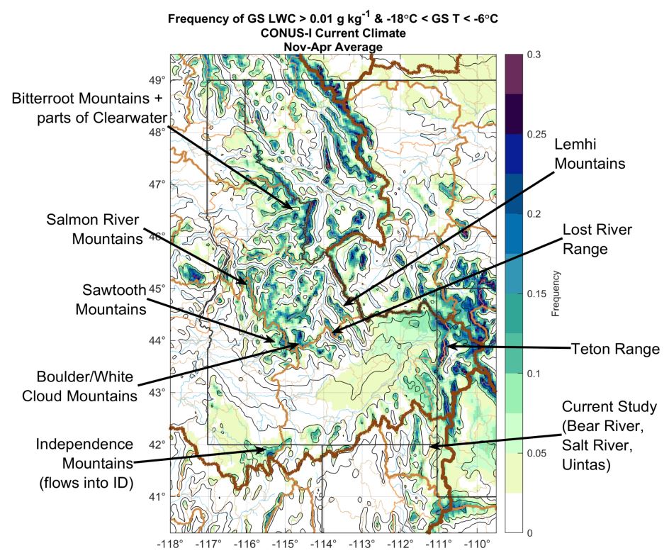
The IWRB directed staff to conduct a statewide assessment of cloud seeding in response to legislation under HB266 (2021), which direct the IWRB to assess the potential for cloud seeding in other regions of the State. This high-level assessment was initiated to determine where there is a frequency of opportunities for cloud seeding that might exist across the State of Idaho. The statewide assessment identified areas where cloud seeding was feasible based on historic weather data. More detailed feasibility and design studies will be required for new basins or regions of interest.
This statewide assessment not only looked into the feasibility of cloud seeding with Silver Iodide (AgI), but also looked into the frequency of opportunities for use of Liquid Propane (LP) as a seeding agent. Like AgI, LP as a seeding agent has been demonstrated in a lab setting to produce ice. However, LP has not yet undergone comprehensive field studies to assess its effectiveness in a broad setting.
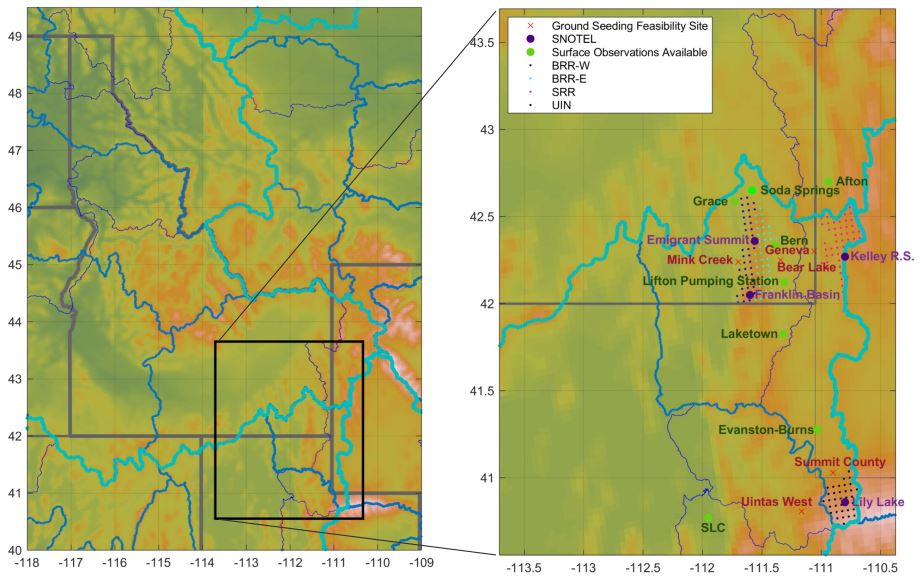
Bear River Basin Feasibility and Design
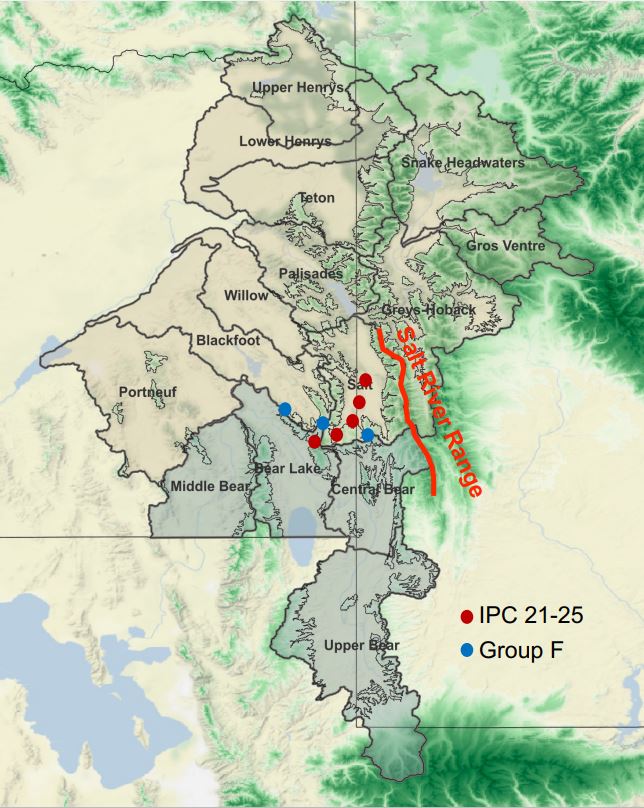
In response to tri-state efforts to support water management in the Bear River Basin, the IWRB directed its staff to conduct a cloud seeding feasibility and design (F/D) study of the Bear River Basin (BRB). The study looks at both ground and aerial seeding opportunities, targeting regions within the Bear that contribute to the fill of Bear Lake, and stream reaches that supply water to Idaho. The study concluded that there exists considerable potential for cloud seeding in the Bear River Basin. The study looked into the question; while a comprehensive ground and aerial program is most effective for optimal water supply enhancement, should costs or other limitations be in place preventing a full scale build out? Aerial operations are optimal over ground operations. Aerial operations are flexible in targeting a variety of storms, don’t require as much capital and implementation resources, and most importantly can more easily overcome mountain flow blocking conditions that are typical of this region.
Upper Snake River/Bear River Basin Shared Feasibility and Design
The IWRB also directed staff to conduct a feasibility and design study of the Bear River Basin (BRB). This evaluation investigates opportunities for shared infrastructure with the Upper Snake River Basin (USRB) cloud seeding project. Sharing Infrastructure with the USRB provides an opportunity to support the BRB, while enhancing operations in the USRB; also allowing for the potential of collaborative funding between both basins.
The study found that some of the USRB existing generators, under respective winds, can be turned on to target either basin and that adding a few more generators along the basin divide may enhance opportunities in both basins.
Lemhi River Basin Feasibility and Design
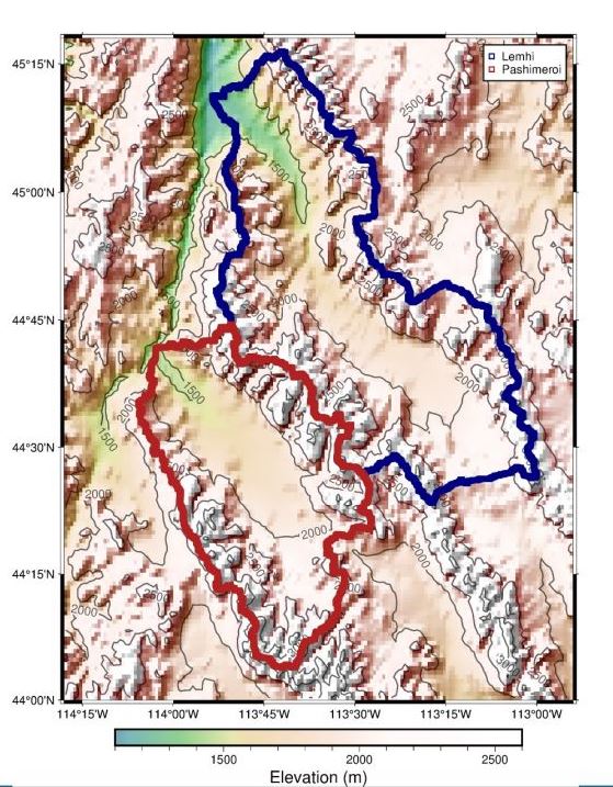
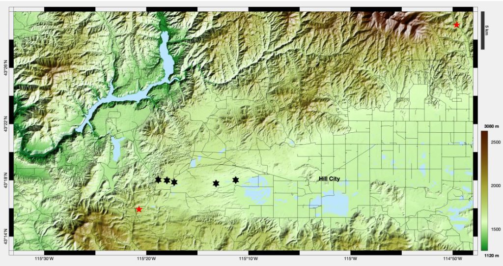
Figure 7. Map of the Lemhi River Basin project area (provided by NCAR)
IWRB directed staff to determine the feasibility of cloud seeding in the Lemhi River Basin to support settlement objectives. This investigation for the feasibility for cloud seeding in the Lemhi River Basin is currently underway. No cloud seeding operations are currently happening in the Lemhi River Basin.
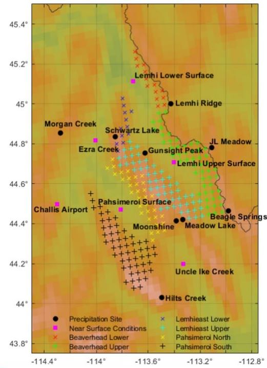
Figure 8. Map of the proposed instrumentation in the Lehmi River Basin (provided by NCAR)
Liquid Propane Pre-Investigation
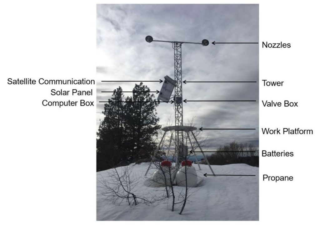
Liquid Propane (LP), like Silver Iodide (AgI), has been demonstrated in lab settings to nucleate ice. Differences are that LP has shown to generate ice at warmer temperatures than AgI and is typically cheaper to use than AgI. This means that ice can form in clouds at warmer temperatures and in younger phases of the cloud, increasing precipitation. The feasibility and efficiency of using LP to support operational cloud seeding projects is presently under investigation.
The IWRB is investigating the efficiency of using LP as either an alternative or enhancement to its operational cloud seeding projects. Coupled with general warming trends in global climatology, LP may be better suited for seeding certain regions in the future.
Many other states and entities have interest in studying the efficacy of using LP for seeding, however broad funding for research to support cloud seeding is still very limited. The IWRB has partnered with Idaho Power Company (IPC), the National Center for Atmospheric Research (NCAR), and CryoToolBox to initiate a Pre-investigation phase.
The first IOP or operational period of the investigation was observed at the beginning of January 2025. Results from the pre-liminary investigation will be used to determine an adequate test site and guide the development for a full-scale investigation of LP as a seeding agent.
Silver Iodide (AgI) Research
This published literature review is collaboratively funded by the 28 member states and public agencies and the North American Weather Modification Council, and is being conducted by Heritage Environmental & Wisconsin State Laboratory of Hygiene (WSEL). This research aims to assess the use of silver iodide (AgI) aerosols released by precipitation enhancement and hail suppression programs in the Western United States. This report is estimated to be available by Fall 2025.

Scope of work
- Calculations of Natural Atmospheric Silver Inputs to Weather Modification Target Regions in the
Western United States - Summary of Natural Silver Abundance in Surface Soils and Freshwater bodies
- Estimates of Silver Iodide Deposited by Weather Modification Programs.
- Review of Silver Toxicity to Terrestrial and Aquatic Organisms
- Discussion of Natural and Weather Modification Related Silver Deposition in Relation to Impacts
on Terrestrial and Aquatic Organisms
Modeling Projects
WRF Model
The Weather Research and Forecasting Model (WRF), originally developed in the late 1990’s, was designed for atmospheric research and operational forecasting. The model can produce a simulation based on actual atmospheric conditions or idealized conditions. This model was developed in a collaborative partnership between the National Oceanic and Atmospheric Administration, the U.S. Air Force, the Naval Research Laboratory, the University of Oklahoma, and the Federal Aviation Administration (FAA).
Here in Idaho, the national WRF model struggles to resolve mountainous terrain. This has required the development of region-specific modeling.
WRF-WxMod (Cloud Seeding Model)
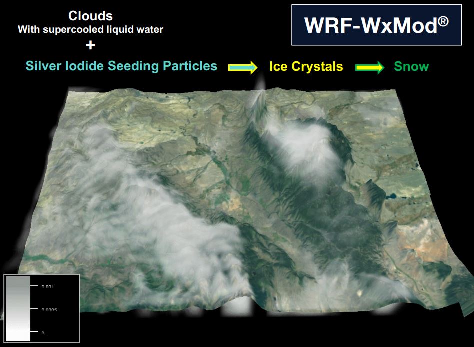
The Weather Research and Forecast Cloud Seeding Model (WRF-WxMod) was initially developed by the National Center for Atmospheric Research (NCAR) with funding support from IPC and the IWRB. This model incorporates cloud seeding parameterizations into the WRF base model. The model can be used to conduct feasibility studies and design new projects, validate existing projects and determine optimization strategies, and/or to forecast cloud seeding opportunities when ran in real-time forecast mode. While more research, data, and model improvements are still required, this model will ultimately be used to better assess the effects of seeding.
WRF-WxMod provides a representation of precipitation over time. This can then be coupled with a hydrological model (WRF-Hydro) to estimate impacts of water generated by cloud seeding operations.
- 2011 | IPC initiated model development for a WRF based cloud seeding model to guide operations. Model development by the NCAR
- 2017 | IWRB began partnering for model development to support on-going operations, and to conduct analysis
- 2023 | IWRB authorized expansion of the WRF-WxMod model to support the Bear River and Lemhi River Basins
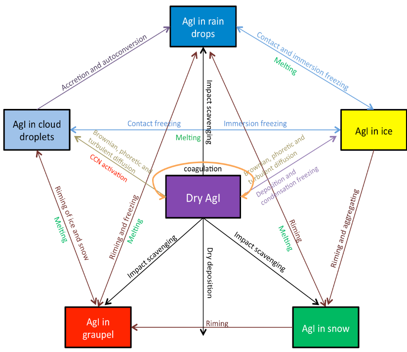
Figure 12. Schematic of the AGI-cloud interactions that are simulated in the seeding parameterization (provided by NCAR)
Figure 11. Diagram of the WRF-WxMod cloud seeding model (image provided by NCAR)
The model is used too:
- Develop seeding criteria for operations
- Planning and design for enhancing or developing new projects
- Conducting assessments
Current IWRB Projects utilizing the model:
- Collaborative Program Operations
- Cloud Seeding Impact Analysis
- Bear River Basin Feasibility and Design
- Upper Snake River Basin / Bear River Basin Shared Infrastructure Assessment
- Lemhi River Basin Feasibility and Design
- Statewide Assessment
- Liquid Propane Investigation (In the future)
Resources:
WRF-Hydro (Hydrology Model)
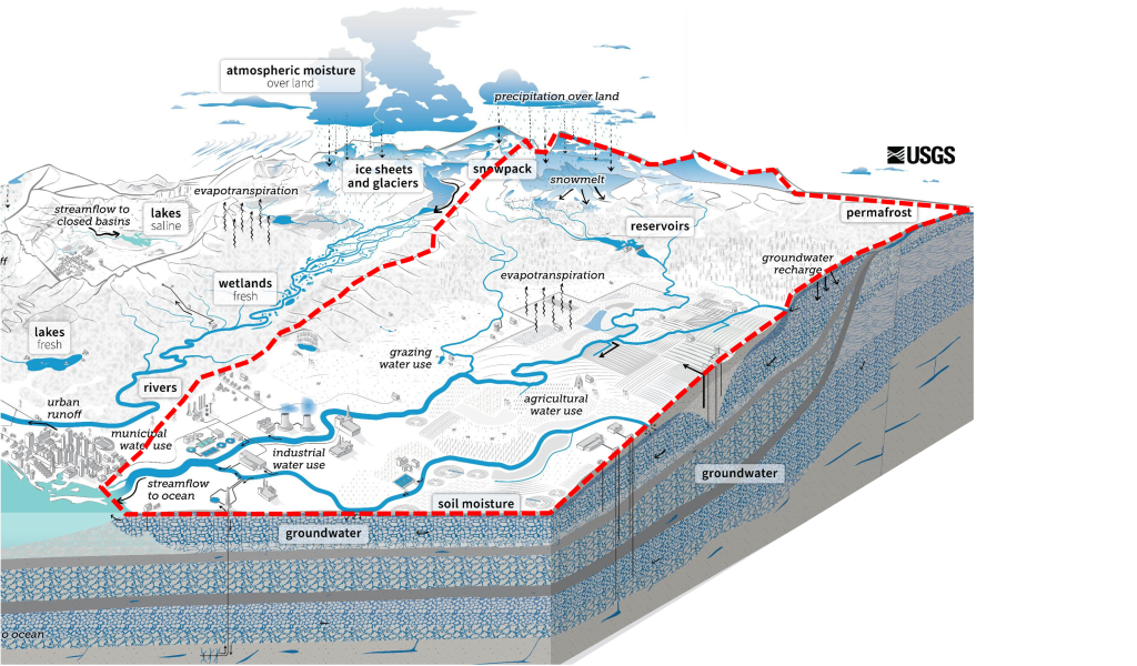
The Weather Research and Forecasting Hydrologic model (WRF-Hydro) is a physically based hydrologic modeling system that produces forecasts and analyses for all major terrestrial water-cycle components. These components include precipitation, streamflow, soil moisture, snowpack, flooding, and groundwater. These forecasts and analyses can be applied to a range of pursuits such as flash-flood prediction, regional hydroclimate impact assessments, seasonal forecasting of water resources, and land-atmosphere coupling studies that supply forecasters, water managers, and government officials with data driven science to better inform their decisions.
The IWRB has invested in this model to support hydroclimate impact assessments for the Cloud Seeding Program. For this model to be efficient in mountainous terrain, it must be calibrated to each region where it used.
Current IWRB Projects utilizing the model:
- Calibration of Upper Snake River Basin
- Calibration of Boise River Basin
- Calibration of Wood River Basin
Other Resources:
RiverWare (Upper Snake River Planning Model)
RiverWare is a streamflow and reservoir regulation model that implements reservoir operations and calibrated hydrologic modeling. This model is used to represent the hydrologic system of the Snake River and provide guidance for water management and planning.
Collaborative efforts are underway between the Idaho Department of Water Resources (IDWR) and IPC to update the model with new improvements from its base platform originally developed by the United States Bureau of Reclamation (USBR). These improvements include reservoir operations, groundwater response functions, diversions, water right accounting, flow augmentation, and recharge.
This model helps the IWRB understand how changes, like an increase in water supply, will affect the system.
High Performance Computing
Lots of models = Lots of computing. Running an abundance of model simulations to support both operations and analysis requires a computer to house the models; and requires a big enough computer to run lots of simulations AND to store data from those simulations.
A High Performance Computer (HPC) was purchased in partnership by the IWRB, IPC, Boise State University (BSU), and the Idaho National Laboratory (INL). This collaborative agreement allows multiple entities to share the costs of a large computing system; and can ultimately serve as a shared resource.
HPC’s, just like a regular desktop computer, have a lifespan beyond which it becomes unreliable. As the modeling needs have grown to support analyses and ongoing operations of the cloud seeding program, the HPC’s capacity has been exceeded. The HPC is additionally nearing the end of its lifespan and will ultimately need to be replaced.
As the IWRB develops its cloud seeding program, there will be a need to determine how much additional computing resources are needed to support the program. New computing solutions are currently being investigated.


