 Official Government Website
What can we help you find?
Upper Salmon Hydrologic Project
Home » Hydrologic Projects » Upper Salmon Hydrologic Project
Hydrologic Projects
- Big Lost River Basin
- Camas Prairie Hydrologic Investigation
- East Ada County Hydrologic Project
- Eastern Snake Plain Aquifer Model
- Mountain Home Plateau
- North Ada County Hydrogeologic Investigation
- Portneuf River Basin Hydrologic Investigation
- Raft River Basin
- Spokane Valley-Rathdrum Prairie Hydrologic Project
- Treasure Valley Groundwater Flow Model
- Upper Salmon Hydrologic Project
- Western Snake Plain Aquifer Model
- Wood River Valley Groundwater-Flow Model
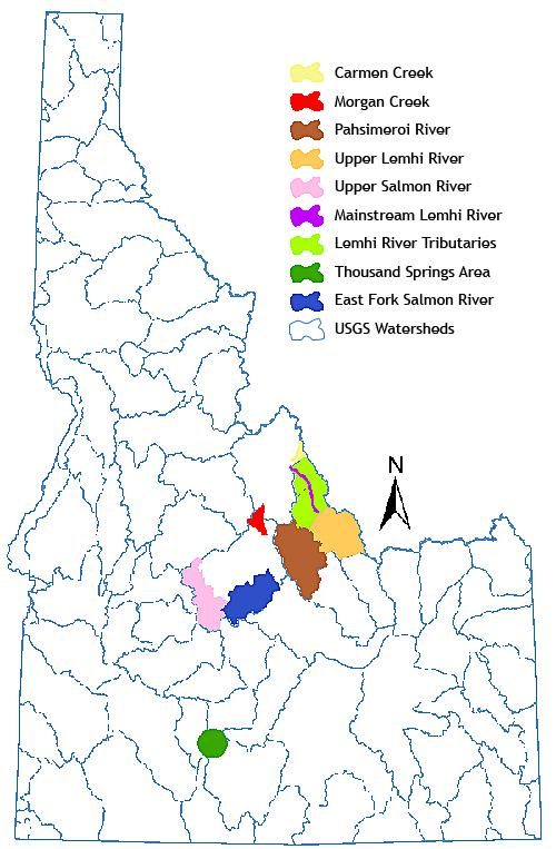
The Idaho Department of Water Resources (IDWR) has been conducting hydrogeologic investigations in the Upper Salmon Basin (Lemhi, Pahsimeroi, East Fork, and headwaters of the Salmon River) from 2007 to present. The project has resulted in a vast hydrogeologic dataset and a series of reports detailing the results of analyses and numerical modeling efforts in the basin.
Data collected includes streamflow, groundwater levels, soil moisture content, groundwater quality, and surface water quality, which is all published online and made available to the public. Hydrogeologic investigations utilizing this data have included evaluation of the potential for streamflow enhancement, characterization of interactions between groundwater and surface water, and prediction of the hydrologic impacts of potential changes to water management and/or use.
Purpose and Objectives
The primary purpose of these investigations is to help the Upper Salmon Basin Watershed Program and other stakeholders to improve salmonid habitat, while respecting and considering the needs of water users and the local economy. In order to do so, this project aims to characterize the hydrogeology of the basin, and to develop and maintain a numerical model that can predict the hydrogeologic, economic, and ecological impacts of changes to the system. Data and analyses from these studies inform salmonid habitat restoration projects and help water users and managers to develop best management practices that provide sustainably supplied, clean water for salmonids and water users alike.
Reference Material for the Upper Salmon Hydrologic Project
Technical Publications
- Hydrologic Monitoring and Analyses, Phase 2 Final Project Report – March 2026
- Hydrologic Monitoring and Analyses, Phase 1 Final Project Report – June 2023
- Groundwater Surface Water Interactions Study, Phase 5 Final Project Report – August 2022
- Groundwater Surface Water Interactions Study, Phase 4 Final Project Report – December 2020
- Groundwater Surface Water Interactions Study, Phase 3 Final Project Report – June 2019
- Groundwater Surface Water Interactions Study, Phase 2 Support Final Report – December 2014
- Groundwater Surface Water Interactions Study – April 2014
- Hydrologic Analysis and Monitoring Phase IV – February 2012
- Optimizing Streamflow Enhancement Phase III – 2010
- Optimizing Streamflow Enhancement Phase II – 2008
Related Links
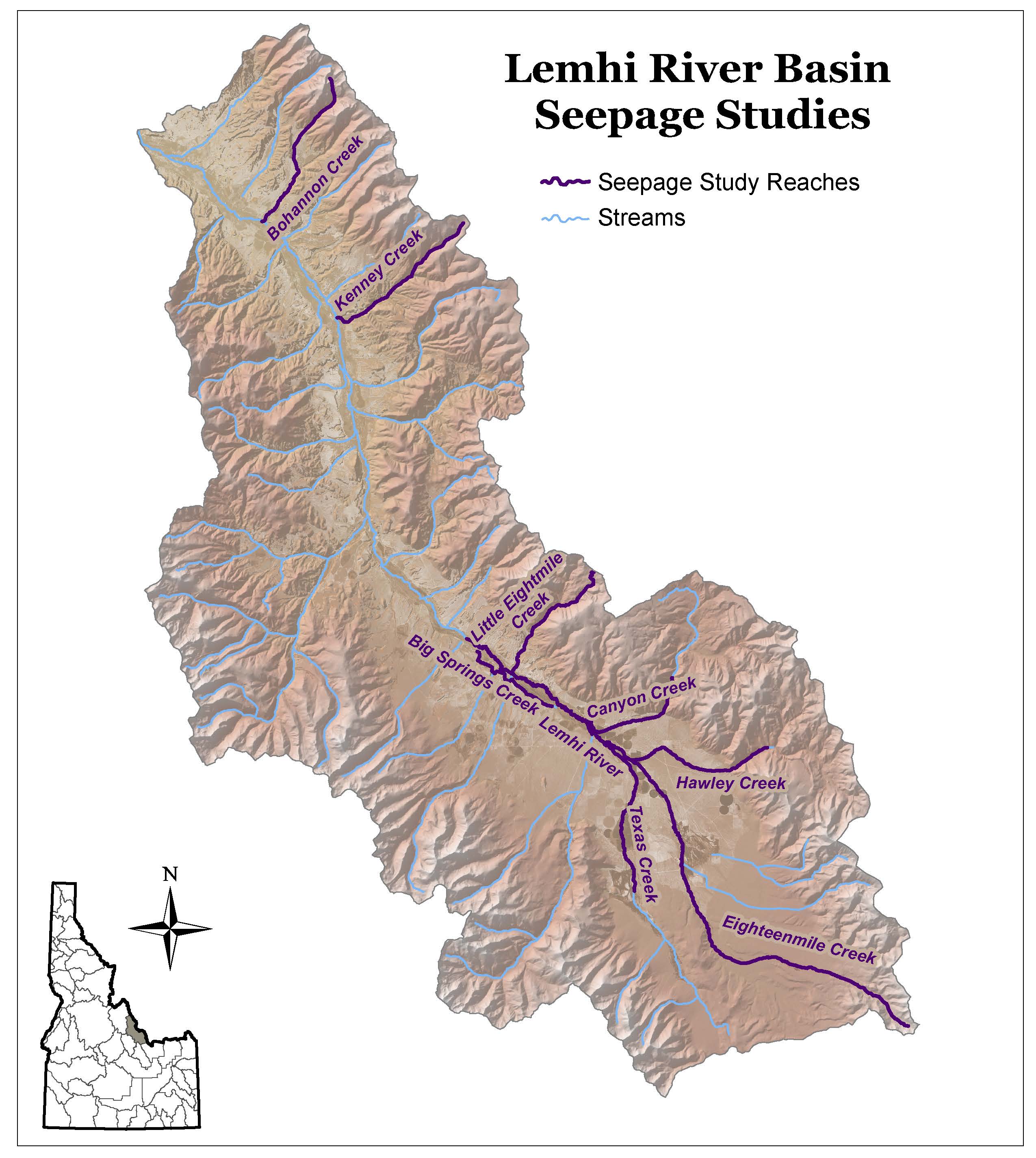
Lemhi River Basin Seepage Studies
Study Information
The seepage studies provided here are brief reports that were incorporated into a final study report for the ongoing Optimizing Stream Flow Enhancement project funded by Pacific Coast Salmon Recovery Fund grants. The seepage studies in the Upper Salmon River Basin were conducted to gain an understanding of the surface water hydrology for a specific stream reach. Specifically, the data was needed to populate hydrology models and to guide decision-making by resource management agencies and landowners.
An understanding of the seasonal and spatial distribution of surface flows, reach gains, and reach loses revealed a greater understanding of the groundwater–surface water interactions. These seepage studies were conducted by measuring stream flow, diversions, surface returns from diversions, and tributary inflows within a short time period (typically one day). Seepage (gain or loss) for a reach was determined by deducting the inflows of tributaries and diversion returns and adding back in the outflows. The results are compared to measured flows at the bottom of the reach or sub-reach. If the calculated water at the bottom of the reach was greater than the measured, then there was a loss of flow to groundwater. If the summed values were less than the measured, then the stream was gaining flow from groundwater. Care was taken to ensure that the study represented gains and losses by monitoring stream gages and by re-measuring the stream flow at the upstream measuring point at the end of the study. This ensured that the differences between measurements were related to groundwater and surface water interaction and not to surface water changes.
- Study Map
- Bohannon Creek
- Canyon Creek
- Eighteenmile Creek
- Hawley Creek
- Kenney Creek
- Lemhi Big Springs Creek
- Little Eightmile Creek
- Little Springs Creek
- Lower Texas Creek
- Upper Lemhi River
Additional Information
Surface Water Modeling Projects
MIKE Basin Modeling Information
The surface water projects listed below use DHI’s MIKE Basin modeling software running in ESRI’s ArcGIS 9.2 or ArcView.